
| Method | |
| Artist | Speed, John |
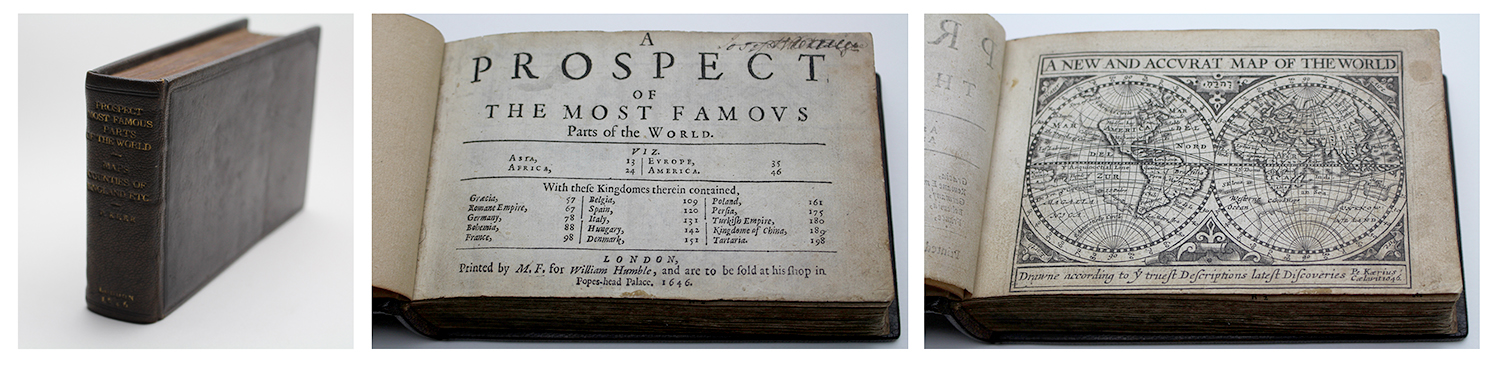
| Published | London, Printed by M.F. for William Humble, and are to be sold at his shop in Popes-Head Palace, 1646. |
| Dimensions | Oblong octavo. 105 x 165 mm |
| Notes |
First thus. Letterpress title-page calling for twenty maps in the Prospect and letterpress index calling for sixty-four [63, as issued] maps in the Theatre, two folding and linen backed with repaired tears and chips. Rebound in early 20th century brown full calf bindings, with panels of original brown calf inset to boards. Gilt lettering to spine attributing the atlas to Keer [sic]. Ex Libris bookplate to pastedown for the antiquarian 'John E. Pritchard. Bristol.' Some internal time toning, minor foxing, manuscript annotations in old hand. Some plates skewed and trimmed close, as issued. An excellent and complete 1646 printing of the so-called 'Miniature Speed' atlas, a composite pocket edition published by William Humble containing reduced versions of both of John Speed's great cartographic achievements, the Prospect of the Most Famous Parts of the World and The Theatre of the Empire of Great Britaine. The atlas contains 83 maps, 20 from the Prospect and 63 from the Theatre, accompanied by Speed's original English commentary from the folio editions of his celebrated atlases, though Speed remains uncredited. The composition of the atlas and the map engravers involved is convoluted, though has been largely unpicked by Koeman and Geoffrey King. The plates of the Prospect, a map of the world in two hemispheres, four maps of the continents, and fifteen maps of the principal kingdoms of the globe, were newly engraved for Humble by the elderly Keere, with this edition their first appearance. The Theatre though is a composite of new and reused plates by a number of hands. Thirty eight of them were reissues of a series of plates Keere engraved for a likely British atlas intended as a companion to the Claesz and Langenes Caert Thresoor, but which remained unused until the 1617 epitome of Camden's Britannia published by Willem Blaeu. Two, the large general map of the British Isles and the folding map of Yorkshire, were engraved by Blaeu to complete the series. By 1619, the Keere and Blaeu plates had passed to George Humble, who issued the first editions of his epitome of Speed's Theatre. Because Keere's original series had been based upon Saxton's county maps, a number of the counties only appeared on combined plates rather than receiving individual treatments as they had in Speed's atlas. As a result, the remaining twenty two plates were engraved by an unknown hand to provide the required number of maps to match Speed's descriptions. Although the index at the back of the Theatre calls for 64 British maps, the map of Midia (Meath) was discontinued in 1627. Collation of maps: Prospect: A New and Accurat Map of the World, Asia, Africa, Europa, America, Ελλας/Greece, The Romane Empire, Germania, Bohemia, Gallia, A New mape of ye XVII provinces of Low Germanie, Hispania, Italia, Hungaria, Dania, Polonia, Persia, The Turkish Empire, China, Tartaria. Theatre Theatre: England Scotland and Ireland, England, Kent, Sussex, Surrey, Southhampton, The Isle of Wight, Dorcetshire, Devonshire, Cornewall, Somersetshire, Wiltshire, Barkshire, Middlesex, Essex Countie, Suffolke, Norfolke, Cambridgeshire, Hartfordshire, Bedfordshire, Buckinghamshire, Oxfordshire, Glocestershire, Herefordshire, Worcestershire, Warwickeshire, Northamptonshire, Huntingtonshire, Rutlandshire, Leicestershire, Lincolneshire, Nottinghamshire, Darbyshire, Staffordshire, Shropshire, Chester, Lancashire, Yorkeshire, The Bishopricke of Durham, Westmorland & Cumberland, Northumberland, The Isle of Man, Holy Island &c., Wales, Pembrokeshire, Radnor Breknock Cardigan and Caermarden described, Glamorganshire, Monmouthshire, Montgomery &c., Denbigh & Flint described, Anglesey and Carnarvan, The Kingdome of Scotland, The South Part of Scotland, The Southern Part of Scotland, The Eastern Part of Scotland, Part of Scotland Stranavern, The Isles of Hebrides, Cathanes and Orknay, Ireland described, Mounster, Leinster, Connaught, Ulster. John Speed (1552-1629) is the most famous of all English cartographers primarily as a result of The Theatre of the Empire of Great Britaine, the first atlas of the British Isles. The maps from this atlas are the best known and most sought-after of all county maps. The maps were derived mainly from the earlier prototypes of Christopher Saxton and John Norden but with notable improvements including parish "Hundreds" and county boundaries, town plans and embellishments such as the coats of arms of local Earls, Dukes, and the Royal Household. The maps are famed for their borders consisting of local inhabitants in national costume and panoramic vignette views of major cities and towns. An added feature is that regular atlas copies have English text printed on the reverse, giving a charming description of life in the early seventeenth century of the region. The overall effect produced very decorative, attractive and informative maps. For the publication of his prestigious atlas, Speed turned to the most successful London print-sellers of the day, John Sudbury and George Humble. William Camden introduced the leading Flemish engraver, Jodocus Hondius Sr. to John Speed in 1607 because first choice engraver William Rogers had died a few years earlier. Work commenced with the printed proofs being sent back and forth between London and Amsterdam for correction and was finally sent to London in 1611 for publication. The work was an immediate success, with the maps themselves being printed for the next 150 years. Speed was born in 1552 at Farndon, Cheshire. Like his father before him he was a tailor by trade, but around 1582 he moved to London. During his spare time Speed pursued his interests of history and cartography and in 1595 his first map of Canaan was published in the "Biblical Times". This raised his profile and he soon came to the attention of poet and dramatist Sir Fulke Greville a prominent figure in the court of Queen Elizabeth. Greville as Treasurer of the Royal Navy gave Speed an appointment in the Customs Service giving him a steady income and time to pursue cartography. Through his work he became a member of such learned societies as the Society of Antiquaries and associated with the likes of William Camden, Robert Cotton, and William Lambarde. He died in 1629 at the age of seventy-seven. Pieter van den Keere (1571-c.1646), also known frequently as Petrus Kaerius, came to England in 1584, as a Protestant refugee from his home town of Ghent with his sister Colette, who married Jodocus Hondius in 1587. It was probably from Hondius that Keere learned to engrave. Both engravers left London in 1593 to settle in Amsterdam. His first set of miniature maps were produced for the Middelburg publisher Cornelis Claesz, for inclusion in Barent Langenes' Caert Thresoor. Keere began to engrave a series of miniature maps in 1599 in preparation for a small atlas of the British Isles. The maps were first published in 1617 by William Blaeu with plate numbers and Latin text. They then passed to George Humble, who published them in 1619 and then again in 1627, by which time they had become known colloquially as 'Miniature Speeds. |
| Framing | Folio |
| Price | £9,000.00 |
| Stock ID | 52047 |