| Method | Copper engraved with early hand colour |
| Artist | Ortelius, Abraham |
| Published | Abrah. Ortelius Regiae Mtis. Geographus describ. cum Privilegijs decennalib. Imp. Reg. et Cancellariae Brabantiae. Antverpiae Ambivaritorum, 1590 [Antwerp, 1591] |
| Dimensions | 312 x 444 mm |
| Notes |
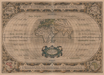
An unusual but highly decorative world map, effectively a Ptolemaic projection of the Old World, from the 1591 German edition of the Additamentum (Addition) to Ortelius' famous Theatrum Orbis Terrarum. The map shows the extent of geographical knowledge as presented in the classical sources. At centre, the old tripartite division of the world into the continents of Europa, Asia, and Africa is depicted, with Europe washed in old hand colour. A small number of cities, including Lutetia (Paris), Rome, Byzantium (Istanbul), Hierusalem (Jerusalem), Alexandria, and Memphis are picked out in red, and forests, mountain ranges, rivers, and lakes are shown pictorially. The southern regions of Africa are missing, though half of Madagascar is featured, and the map stretches as far east as the South East Asian peninsula, but does not include China. These geographical features are embedded in a much larger empty oval, intended to show, as Ortelius' explains in his commentary, that the extent of classical geographical knowledge covers only a fraction of the actual surface of our globe. The remaining space is instead used to illustrate the various 'zones' of the world, a popular subject in ancient philosophy, and early Christian theosophy. The zone north of Hyperborea, essentially the Arctic circle, is described as a frigid region, void of life. Below this, the zone between the Arctic Circle and the Tropic of Cancer is the temperate zone, inhabited by the various races of the ancient Mediterranean and Near East. On either side of the Equator, between the Tropics of Cancer and Capricorn is another area described by the ancients as inhospitable, due to the belief that the intensity of the Sun made life impossible. Of most interest is the fourth zone, which, although completely unknown and unexplored in the classical era, was rightly theorised to be habitable, sharing a similar climate to that of the northern temperate zone. The map is surrounded by an elaborate fretwork border, in which are embedded a set of four roundel maps of the Continents, a large title cartouche, and an exhortation, below, that the spectator of this map enjoy this puzzle of the world, and wonder at the impact that the Columbus' discoveries in 1492 on our knowledge of the world. The map is a curious work of classical philological erudition, first issued in 1590 as part of the Additamentum, but rapidly becoming part of Ortelius' Parergon (Supplement). By the time of its final Parergon printing in 1624, the extensive notes on the verso of the map collate as many references as Ortelius was able to find regarding the science of geography in Antiquity, from Anaximander's creation of the first map, to traveller's tales of globes, tables, and charts in use across the Greek and Roman world. Some seventeen authors are included in the list, providing a remarkable thorough index of geographical achievement, from Egyptian cosmography, Babylon, and Carthage, to Byzantium, the court of Charlemage, and Dominicanus of Colmar's 13th century World Map. The Parergon ('Supplement') was, as the title suggests, originally conceived of as a supplement to Ortelius' Theatrum. The work, a massive and intricately researched index of the classical world, was accompanied by a series of ancient world maps. Unlike the maps of the Theatrum, the majority of which were reductions of earlier maps, the maps of the Parergon were researched and drawn by Ortelius himself. The work was a huge commercial success, and the maps themselves set the standard for ancient world maps for the duration of the seventeenth century, being reproduced or reprinted by various publishers after Ortelius' final 1624 printing. His interest in the mapping of the ancient world is manifest. The maps of the Parergon are a veritable mine of textual commentary and classical philology, drawing upon Ptolemy, Strabo, Pliny, and many others. Interestingly, the project seems to have been a labour of love, rather than a mercantile venture. Ortelius himself was fascinated with the ancient world, and a formidable classical scholar in his own right. In addition to his work as a cartographer, he dealt in antiquities, visited and surveyed ancient sites across Europe, published a critical edition of Caesar's Gallic Wars in 1593, and assisted Welser in his studies of the famous Tabula Peutingeriana in 1598, producing an engraved copy of the map that can be found in later editions of the Parergon. Abraham Ortelius (1527 -1598) was a Flemish cartographer, cosmographer, geographer and publisher and a contemporary of Gerard Mercator, with whom he travelled through Italy and France. Although it is Mercator who first used the word "Atlas" as a name for a collection of maps, it is Ortelius who is remembered as the creator of the first modern atlas. Theatrum Orbis Terrarum was the first systematically collated set of maps by different map makers in a uniform format. Three Latin editions as well as a Dutch, French and German edition of Theatrum Orbis Terrarum were published by 1572 and a further 25 editions printed before Ortelius' death in 1598. Several more were subsequently printed until around 1612. Ortelius is said to have been the first person to pose the question of the continents once being a single land mass before separating into their current positions. Condition: Central vertical fold, as issued. Acid burn from old mount to margins, not affecting map. Some surface dirt and abrasion to map. German blackletter letterpress text on verso. |
| Framing | unmounted |
| Price | £1,200.00 |
| Stock ID | 53133 |

