| Method | Copper engraved with hand colour |
| Artist | von Reilly, Franz Johann Joseph |
| Published | Gestochen von Johann Stenger. Zu finden im von Reillyschen Landkarten und Kunstwerke Verschleiss Komtoir in Wien [Vienna, 1799] |
| Dimensions | 460 x 355 mm |
| Notes |
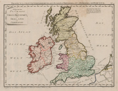
A late eighteenth century German map of the British Isles, engraved by Johann Stenger for von Reilly's expansive atlas, Schauplatz der fünf Theile der Welt. The map is ornamented in wash colour, with regional and county boundaries outlined in hand colour. Above the map, a Latin superscript title reads: 'Prospectus cursuum veredariorum, qui in Magna Britannia, et Hybernia reperiuntur.' Franz Johann Joseph von Reilly (1766-1820) was an Austrian publisher, cartographer, and writer. Reilly produced over 830 maps for his great atlas project, "Schauplatz der funf Theile der Welt" between the years 1789 and 1806. Of these 830 maps published over this time span of seventeen years, he 'showcased' only one part of the world, Europe. Maps of the other four continents remained unpublished. The maps of the "Schauplatz ..."were drawn to a uniform criteria. Johann Stenger (1767-18020 was an Austrian engraver and printmaker, active in Vienna. Condition: Minor surface creasing to sheet. Time toning to edges of sheet. |
| Framing | unmounted |
| Price | £275.00 |
| Stock ID | 52905 |

