| Method | Copper engraved |
| Artist | Porro, Girolamo after Magini, Giovanni Antonio |
| Published | [Arnhemii Excudebat Ioannes Ianssonius, Anno 1617] |
| Dimensions | 122 x 168 mm |
| Notes |
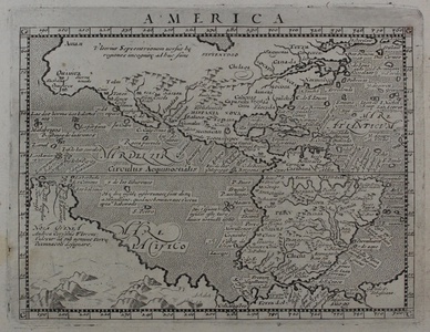
A map of North and South America, from the 1617 Latin printing of Giovanni Antonio Magini's edition of Claudius Ptolemy's Geographia, published by Jan Jansson. The map, based upon the first of Ortelius' maps of the Americas, and following the geography of Giovanni Lorenzo d'Anania, is most notable for retaining the distinctive and erroneous extra bump on the southern west coast of South America. By contrast, the Californian peninsula is mapped correctly, rather than as an island. To the left and bottom edges of the map, the large landmass of Terra Incognita combines parts of the coasts of Antarctica, Australia, and New Guinea. Girolamo Porro (c. 1520-1604) was an Italian engraver active in Venice and his native Padua, working predominantly as a map engraver for Tommaso Porcacchi, and Girolamo Ruscelli. Giovanni Antonio Magini (1555-1615) was an Italian scientist, cartographer, and chair of mathematics at the University of Bologna. A prominent geocentrist, he was a correspondent of many notable contemporaries, including Tycho Brahe, Kepler, and Ortelius. His commentary on Ptolemy's Geographia, with accompanying copper-plate maps by Porro, appeared in Latin in its first edition in 1596, with the first Italian translation by Leonardo Cernoti printed in 1598. Johannes Janssonius (1588 - 1664) was a famed cartographer and print publisher. More commonly known as Jan Jansson, he was born in Arnhem where his father, Jan Janszoon the Elder, was a bookseller and publisher. In 1612 he married the daughter of the cartographer and publisher Jodocus Hondius, and then set up in business in Amsterdam as a book publisher. In 1616 he published his first maps of France and Italy and from then onwards, produced a very large number of maps which went some way to rival those of the Blaeu family, who held a virtual monopoly over the industry. From about 1630 to 1638 he was in partnership with his brother-in-law, Henricus Hondius, issuing further editions of the Mercator/Hondius atlases to which his name was added. On the death of Hondius he took over the business, expanding the atlas still further, until eventually he published an eleven volume Atlas Major on a scale similar to Johannes Blaeu's magnum opus. After Jansson's death, his heirs published a number of maps in the Atlas Contractus of 1666, and, later still, many of the plates of his British maps were acquired by Pieter Schenk and Gerard Valck, who published them again in 1683 as separate maps. Condition: Latin text on verso, some minor toning to sheet. |
| Framing | mounted |
| Price | £700.00 |
| Stock ID | 47914 |

