| Method | Copper engraved with hand colour |
| Artist | Blaeu, Willem Janszoon |
| Published | Auct: Guiljelmo Blaeuw. Cum privilegio decem annorum [Amsterdam, 1644] |
| Dimensions | 405 x 550 mm |
| Notes |
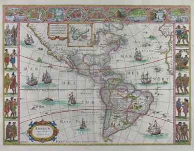
A beautiful example of one of Blaeu's famous carte-a-figures maps, this example depicting the Americas. Blaeu's carte-e-figures maps of the world and the four continents are some of his most desirable. Reduced versions of the set of five wall maps he published in 1608, each example features a border of vignettes of principal cities, as well as depictions of pairs of figures in the national dress of the kingdoms and races of each continent. This particular example is from the 1644 Le Theatre du Monde, a French printing of the Atlantis Appendix. The map encompasses the majority of the New World, stretching from the Davis Strait in the north to the Straits of Magellan and the Tierra del Fuego in the south. In the earliest state of the map, Blaeu had attached the Tierra del Fuego to the putative coastline of Terra Australis. Despite the findings of le Maire and Schouten, that the Tierra del Fuego was an island, Blaeu was prevented from updating his design by the East India Company and had to wait until late 1618 to update it to the state seen in this example. Curiously the label 'Terra Australis Incognita' remains along the bottom margin, though the coastline of the Southern Continent has been erased. Unlike many of the maps by his near contemporaries, Blaeu's northwestern coast is fully mapped and California is shown correctly as a peninsula, rather than as an island, even in later printings of the map. An inset map at top centre extends the map to the Pole, encompassing Greenland, Iceland, and the mythical Frisland, while along the top right edge of the map, the western extremities of Europe and Africa are shown. The seas are populated with sailing ships and sea monsters, a tribe of cannibals host a barbecue in the interior of Brazil, and a Patagonian giant meets a figure in European dress. Along the sides of the map is an elaborate pictorial border, featuring the national dress of the pre-Columbian people of Greenland, Virginia, Florida, Nova Albion (California), Mexico, Peru, Brasil, the Moche, and Magellanica. The top border encloses a series of nine vignettes of the principal cities of the continent: Havana, Santo Domingo, Cartagena, Mexico (Tenochtitlan), Cusco, Potosi, Mocha Island in Chile, Rio de Janeiro, and Olinda. The Blaeu family were one of the most famous publishers of maps, globes and atlases during the seventeenth-century. Cartographers, globe makers and booksellers, the Blaeu business flourished in Amsterdam for over 40 years, until a fire destroyed their premises in 1672. They lost all of their plates, prints and stock, which effectively ruined the firm. Willem Blaeu founded the business in 1596. It initially functioned as a globe and instrument makers, but soon expanded into maps, topography and sea charts. The Atlas Novus was Willems great work; a major work which intended to include the most up-to-date maps of the entire world. He issued the first two volumes in 1635, but died in 1638 before the atlas was completed. The running of the business was passed on to his sons Johannes and Cornelis, in addition to the role of the official cartographer of the East India Company. After the death of Cornelis in 1644, Johannes continued the business alone and established his own reputation as a great mapmaker. Johannes completed his father's grand project in 1655 with the sixth and final volume of the Atlas Novus. He also produced the Tooneel der Steden van der Vereenighde Nederlanden in 1649-1653, as well as a similar set of Italian town plans which were published in 1663. Burden 189 (iv/v) Condition: Pressed central vertical fold, as issued. Minor creasing to central fold. Minor time toning to edges of sheet, not affecting map. Strong impression with full margins. French text on verso. |
| Framing | framed |
| Price | £4,500.00 |
| Stock ID | 50991 |

