| Method | Copper engraved with original hand colour |
| Artist | Bowen, Emanuel |
| Published | 1751 |
| Dimensions | 524 x 703 mm |
| Notes |
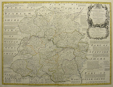
Impressive large scale map of Shropshire taken from Bowen & Kitchin's The Large English Atlas. The work contains a large decorative cartouche on the right, with a dedication to the Right Honourable Henry Arthur Herbert below. Inscription below title reads: Drawn and Compiled from the most approved Maps & Surveys & Illustrated with various additional improvements. Also, Historical extracts relative to Trade, Manafactures, Natural History &c not Extant in any other Map of this County. Emmanuel Bowen (c.1693 -1767) was one of the leading eighteenth-century map and print sellers and engravers in London. Appointed Engraver of maps to George II of England and possibly Louis XV of France; his apprentices included Thomas Kitchin and Thomas Jeffreys. Bowen collaborated with other map makers of his time, including the Bowles family and John Owen. Condition: Vertical centre fold as issued. |
| Framing | unmounted |
| Price | £400.00 |
| Stock ID | 28190 |

