| Method | Copper engraved with original hand colour |
| Artist | Weigel, Christoph |
| Published | excusa a Christopho Weigelio, Norimbergae [Nuremberg, c.1718] |
| Dimensions | 405 x 335 mm |
| Notes |
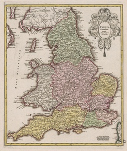
Weigel's map of England and Wales, ornamented in original hand colour in the Nuremberg style, from his popular Bequemer Schul- und Reisen-Atlas, also known as the Atlas scholasticus et itinerarius. The map is credited by Weigel to William Camden, as it follows Camden's historical divisions during the so-called Anglo-Saxon heptarchy, with the Kingdoms of Northumbria, Mercia, East Anglia, Essex and Middlesex, Kent, Surrey, and Wessex outlined in hand colour. The borders of the historic counties are shown as dotted lines, and principal towns and cities are shown. In the top right, a decorative title cartouche features 5 emblematic roundels. Christoph Weigel (1654-1725) was a German mapmaker, publisher, and art dealer, known mostly for his travel atlases, and active in Nuremberg. Johann David Köhler (1684-1755) was a German historian, best known for his work on Roman coins and general historical numismatics, ancient weaponry, and genealogy. William Camden (1551-1623) was an English historian, author, topographer, herald, and antiquarian. Camden's most celebrated work was the "Britannia", the first chorographical study of the British Isles, and a watershed moment for British antiquarianism. William Camden's great Renaissance work 'Britannia' was originally published in Latin in 1586, providing a historical and topographical study of Great Britain. His stated intention was to "restore antiquity to Britaine, and Britain to his antiquity". Camden was interested in the means by which Britain's history was etched upon its contemporary landscape, and as such, the Britannia was more than a simple history. Condition: Minor creasing and chips to margins, not affecting map. Manuscript page number to bottom right margin, in old hand. Blank on verso. |
| Framing | unmounted |
| Price | £300.00 |
| Stock ID | 52856 |

