
| Method | Copper engraved |
| Artist | Morden, Robert |
| Published | 1676 - c. 1773 |
| Dimensions | 93 x 58 mm |
| Notes |
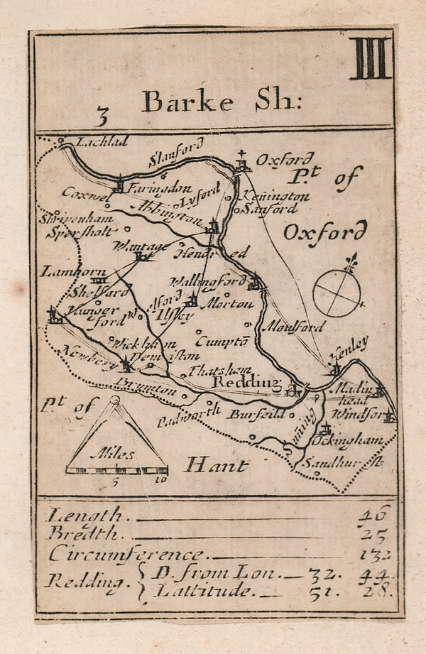
A very rare playing card map of the county on a scale of five-eighths of an inch to 10 miles. A compass rose to the middle right and mile scale below the map, the Roman numeral 3 in the upper right corner. An engraved legend of the length, breadth and circumference of the county alongside the distance from London to Reading and the latitude position of the city is listed below. Robert Morden's set of playing cards first appeared in 1676 in a set entitled 'The 52 Counties of England and / Wales, Geographically described / in a pack of Cards, / Whereunto is / added ye Length. Breadth. & Circuit. / of each County the latitude the Scitu- / ation and distance from London of ye / principal Cities, Towns. and Rivers. / with other Remarks as plaine and / ready for the playing of our Eng- / lsh Games as any of ye Common / Cards.'; the second set of English playing cards to show maps and the first series of county maps to include roads (which were taken from Ogilby's Britannia of 1675). There was a further edition in 1676 published with the addition of the names of adjoining counties added outside the county boundary. A third edition by Morden and Pask in 1680 included additional place names and roads on some of the maps. The plates reappeared around one hundred years later in the hands of London publisher, Homan Turpin, who printed the cards without suit marks, but with a page of accompanying text giving county history, in the form of a small atlas. This impression of the playing card map is from Turpin's atlas 'A Brief Description Of England and Wales; Containing A particular Account of each County; With its Antiquities, Curiosities, Situation, Figure, Extent, Climate, Rivers, Lakes, Soils, Agriculture, Civil and Ecclesiastical Divisions, Cities, Towns, Palaces, Corporations, Markets, Fairs, Manufactories, noted Places, Bays, Harbours, Products, &c. and the Number of its Inhabitants. As Also, The Distance of each Market Town from London, by the latest Survey, with the Latitude and Longitude of each County, Town or City, and on what Point of the Compass from London. Embellished with Maps of each County. Very useful for Travellers and others, and very proper for Schools, to give Youth an Idea of Geography, and the Nature of his own Country, and each County. London: Printed for H. Turpin, No.104, St. John's Street, West Smithfield.' Homan Turpin was in business at this address 1764-87; the publication is not listed in his catalogues of 1770 and 1772. Robert Morden (c. 1650-1703) was an English bookseller and publisher, as well as an accomplished geographer and cartographer. He is best known for a series of maps issued in 1695 in Gibson's revised edition of Camden's Brittannia,' engraved by Sutton Nicholls . Condition: Excellent clean impression laid to another sheet of 18th century paper as issued. |
| Framing | unmounted |
| Price | £450.00 |
| Stock ID | 52752 |