
| Method | Copper engraved with early hand colour |
| Artist | Rocque, John |
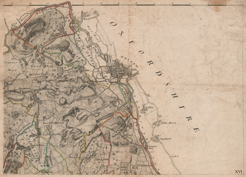
| Published | [By J. Rocque, Topographer to His Majesty, London. Printed for and Sold by the Author, near Old Round-Court, in the Strand. MDCCLXI] |
| Dimensions | 350 x 480mm |
| Notes |
A single sheet of Rocque's large scale survey of the county of Berkshire, this particular sheet centred on Oxford and the River Isis. The city of Oxford is shown in plan, with the footprints of the Colleges and Public buildings of the University shaded in black. Most of the adjoining part of Oxfordshire is blank, apart from Wolvercote, Binsey, Iffley, Littlemore, and Sandford. On the eastern side of the river, the parishes of Berkshire are outlined in hand colour, with detail of each building, farm, field, and wood shown and labelled. The full survey, published in 1761, is the most impressive eighteenth century map of Berkshire, and the first of a series of three that Rocque planned but never completed, with the surveys of Buckinghamshire and Oxfordshire incomplete at the time of his death the following year. John Rocque (1709-1762) was a Hugenot refugee who came to England as a baby in 1709 with his parents, fleeing persecution in France. In addition to his work as surveyor and mapmaker, Rocque was an engraver and map-seller. He was also involved in gardening as a young man, living with his brother Bartholomew, who was a landscape gardener, and producing plans for parterres, perhaps recording pre-existing designs, but few details of this work are known. Rocque produced engraved plans of the gardens at Wrest Park (1735), Claremont (1738), Charles Hamilton's naturalistic landscape garden at Painshill Park, Surrey (1744), Wanstead House (1745) and Wilton House (1746). Rocque is now mainly remembered for his Map of London, published in twenty four sheets in 1746. It was by far the most detailed map of London published up to that time, and remains the most detailed map of eighteenth century London today. Rocque also published another smaller-scale map of London in sixteen sheets at the same time. His success as a cartographer brought him the appointment as cartographer to Frederick, Prince of Wales in 1751. A fire in 1750 destroyed his premises and stock, but by 1753 he was employing ten draughtsmen, and published The Small British Atlas: Being a New set of Maps of all the Counties of England and Wales. Rocque's 1756 map of Dublin featured on an Irish ten pound bank note. He married twice. His widow continued the business after his death. Condition: Central horizontal and vertical folds. Creasing, staining, and time toning to sheet. Marginal tears and chips, some into plate. Blank on verso. |
| Framing | unmounted |
| Price | £275.00 |
| Stock ID | 52675 |