| Method | Copper engraved with hand colour |
| Artist | Blaeu, Johannes |
| Published | [Amsterdam, c. 1645] |
| Dimensions | 410 x 520 mm |
| Notes |
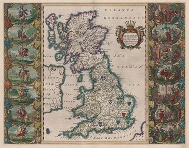
A superb and historically significant map of the British Isles at the time of the Anglo-Saxon heptarchy, engraved for a French edition of the Blaeu Atlas. The map was first issued in 1645 in the fourth volume of the Atlas Novus, which covered England and Wales, and was based on the John Speed map of the Heptarchy from 1611. A very close copy of Blaeu's map was subsequently issued by Blaeu's competitor Jan Jansson the following year. The main difference between the Dutch examples and the Speed map are the vignettes down the left and right margins, which, while unchanged in terms of subject, have been re-engraved in a distinctively ornate Dutch manner. The map itself shows the whole of Great Britain, along with the eastern half of Ireland, and a small section of Gallia (France) in the bottom right. The borders of Wales, Scotland, and Ireland are relatively unchanged from Blaeu's contemporary seventeenth century, though Scotland features a pair of armorials for the 'Kingdom of the Scots' in the north and the 'Kingdom of the Picts' in the south. The biggest difference cartographically is the division of England into the seven Anglo-Saxon kingdoms active during the 5th to 7th centuries. Each features an armorial crest. Compass roses and sailing ships decorate the seas around the islands, and the title is enclosed in a baroque strapwork cartouche supported by a pair of winged cherubs and surmounted by a seven-sceptred crown. The large figural panels to the left and right of the map show the kings of the seven kingdoms. The seven pagan kings, Hengist, Aella, Cerdic, Aescwine, Ida, Wuffa, and Creoda, as well as the foundation dates of their respective kingdoms, are included along the left hand margin, while the right hand panel shows the conversion or matyrdom of the kings associated with the spread of Christianity in the Anglo Saxon period: Aethelbert, Saeberht, Eorpwald, Edwin, Cynegils, Peada, and Aethelwealh. The Blaeu family were one of the most famous publishers of maps, globes and atlases during the seventeenth-century. Cartographers, globe makers and booksellers, the Blaeu business flourished in Amsterdam for over 40 years, until a fire destroyed their premises in 1672. They lost all of their plates, prints and stock, which effectively ruined the firm. Willem Blaeu founded the business in 1596. It initially functioned as a globe and instrument makers, but soon expanded into maps, topography and sea charts. The Atlas Novus was Willems great work, a major work which he intended to include the most up-to-date maps of the entire world. He issued the first two volumes in 1635, but died in 1638 before the atlas was completed. The running of the business was passed on to his sons Johannes and Cornelius, in addition to the role of the official cartographer of the East India Company. After the death of Cornelis in 1644, Johannes continued the business alone and established his own reputation as a great mapmaker. Johannes completed his father's grand project in 1655 with the sixth and final volume of the Atlas Novus. He also produced the Tooneel der Steden van der Vereenighde Nederlanden in 1649-1653, as well as a similar set of Italian town plans which were published in 1663. Shirley 552 Condition: Central vertical fold, as issued. Acid burn from old mount to margins, outside platemark. French letterpress text on verso. |
| Framing | unmounted |
| Price | £3,000.00 |
| Stock ID | 53130 |

