| Method | Copper engraved |
| Artist | Morden, Robert |
| Published | Iohn Sturt sculp. [London, c.1722] |
| Dimensions | 375 x 300 mm |
| Notes |
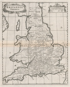
A detailed map of England and Wales at the time of the Anglo Saxon heptarchy, engraved by John Sturt for the Gibson edition of Camden's 'Britannia. The map's divisions are mostly recognisable as corresponding to the historic counties, though place names are given in Old English and written in a stylized uncial. Hadrian's wall, incorrectly labelled here as the 'Severan Wall,' is shown as a double line crossing from Tinan myth (Tynemouth) to Karleol (Carlisle), and in the North Sea, a number of Viking ships with their characteristic dragon headed prows can be seen. Camden's 'Britannia', enhanced by the addition of the Kip/Hole maps, had been enthusiastically received in 1607, encouraging further additions in 1610 and 1637. It is therefore surprising that it was not until 1695 that a new edition appeared edited by Edward Gibson and illustrated by a series of maps by Robert Morden. Despite glowing reports in the preface of maps either prepared from new surveys or 'newly revised' there was very little originality about them, except the addition of roads from Ogilby's survey of 1675. This was in fact the first county atlas to incorporate this information. There were five editions of the 'Britannia' with Morden's maps, 1695, 1722, 1730, 1753 and 1772. William Camden (1551-1623) was a historian and antiquary whose works were reprinted and published over a period of 200 years. The original Latin text was first translated by Gibson in 1695. Morden was employed to replace the outdated maps by Saxton, engraved by Kip and Hole. He based his maps on manuscript sources plus the surveys of Ogilby and Morgan, Seller, Palmer and the coastal charts of Cpt. Greenville Collins. One of his original contributions to cartography was the showing of longitudes measured from the meridian of St. Paul's Cathedral given in the form of time in minutes at the top of the map in Roman numerals and at the bottom in degrees. This was done to clarify local times that were taken from the sun as there was no national standard time. Robert Morden (c. 1650-1703) was an English bookseller and publisher, as well as an accomplished geographer and cartographer. He is best known for a series of maps issued in 1695 in Gibson's revised edition of Camden's Brittannia,' engraved by Sutton Nichols. Condition: Central horizontal fold, as issued. Minor time toning to central fold. Blank on verso. |
| Framing | unmounted |
| Price | £225.00 |
| Stock ID | 52854 |

