| Method | Copper engraved with early hand colour |
| Artist | Weigel, Christoph |
| Published | Norimbergae excudit C. Weigelius [Nuremberg, c.1718] |
| Dimensions | 330 x 315 mm |
| Notes |
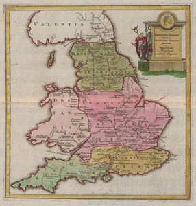
Weigel's map of Roman Britain, ornamented in early wash colour in the Nuremberg style, from his popular Bequemer Schul- und Reisen-Atlas, also known as the Atlas scholasticus et itinerarius. The map is credited by Weigel to the seventeenth century classicist Thomas Gale, Regius Professor of Greek at Cambridge. Despite the map's title cartouche suggesting an Antonine date, the division of England and Wales into four provinces took place under the Diocletianic Reforms a century later. Hadrian's wall, shown pictorially, marks the boundary between Britain proper and Valentia (Scotland). The title cartouche in the top right corner of the map takes the form of a monumental stone altar, featuring a roundel of a bearded Antonine. Beside this, an Emperor in military dress stands before the eagles of the legions. Christoph Weigel (1654-1725) was a German mapmaker, publisher, and art dealer, known mostly for his travel atlases, and active in Nuremberg. Johann David Köhler (1684-1755) was a German historian, best known for his work on Roman coins and general historical numismatics, ancient weaponry, and genealogy. Condition: Central horizontal fold, as issued. Minor creasing and time toning to sheet. Blank on verso. |
| Framing | unmounted |
| Price | £250.00 |
| Stock ID | 52857 |

