| Method | Lithograph with original hand colour |
| Artist | Bartholomew, John |
| Published | A. Fullarton & Co. Edinburgh, London & Dublin [c.1862] |
| Dimensions | 425 x 530 mm |
| Notes |
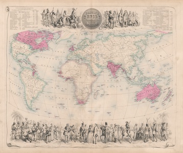
A fine example of one of the most sought-after Victorian maps of the British Empire, engraved by John Bartholomew Jnr for Archibald Fullarton's Royal Illustrated Atlas of the Modern World. The map shows the British Empire just before its zenith, encompassing colonial holdings in Ireland, Canada, the Caribbean and South America, West Africa and the Cape, India and the East Indies, Hong Kong, Australia, New Zealand, and Oceania. As is customary, Imperial possessions are coloured red and engraved in bold. Sea coasts and borders outside British dominion are coloured green, except Africa, perhaps suggestive of the imperial ambitions of the various European powers at the time. Above and below the map are a series of vignettes engraved by Thom, depicting the various peoples of the Empire. Along the top, Aboriginal Australians stand behind a group of settlers, while American frontiersmen speak to a group of First Nations people described in the inscription as 'copper coloured.' In the bottom border are representatives of the Raj and British China, a group of British sailors, a Scotsman, a gentleman and lady, a cavalryman with his horse and sabre, and native peoples of Cape Colony (South Africa). In the top right and left corners, tables feature extensive data for the populations and area in square miles of British possessions across the globe. The Royal Illustrated Atlas of the Modern World was first published as a single atlas in 1864, having been issued as 27 individual parts from 1854 to 1862. The majority of its maps were engraved by Bartholomew, featuring highly decorative vignettes of peoples and places. The atlas is significant for being the last highly decorative atlas to be published in Britain, as Victorian imperial ambitions had resulted in a renewed focus on accuracy rather than aesthetic in the creation of maps. The atlas went through numerous different editions, making dating of individual maps difficult. The majority of Fullarton's maps of the British Empire date throughout the period from 1864 to 1872, the dates of each edition usually estimated by the absence or appearance of various Australian states. Unusually, all known copies of the British Empire map feature a slim territorial holding in Papua New Guinea, though annexation of the region by Queensland did not formally take place until 1883, some 20 years after the publication of the first of Fullarton's maps. John Bartholomew & Son was founded by John Bartholomew Senior (1805 - 1861) in 1826. Initially the firm printed maps for external companies, though under John Bartholomew Junior and his son John George Bartholomew, the company achieved much greater success after making the decision to commission and print their own map series. In particular, the firm was responsible for the Times Survey Atlas of the World (1922) and successive Times Atlases. Archibald Fullarton and Company were a Glasgow based publisher operating towards the end of the nineteenth century. The company produced a number of atlases, and books containing maps, including Fullarton's Parliamentary Gazetteer Of England And Wales and The Royal Illustrated Atlas, Of Modern Geography. These publications featured attractively decorated maps, with small vignette views of local interest surrounding the engraved map. Condition: Central vertical fold as issued. Minor dirt build-up and toning to sheet. |
| Framing | unmounted |
| Price | £1,000.00 |
| Stock ID | 52825 |

