| Method | Copper engraved with hand colour |
| Artist | Luneau de Boisjermain, Pierre-Joseph |
| Published | Par Mr. l'Abbe Luneau De Boisjermain MDCCLX. Avec Privilege du Roy. a Paris chez l'Auteur rue et a cote de la Comedie Francoise [Paris, 1760] |
| Dimensions | 580 x 820 mm |
| Notes |
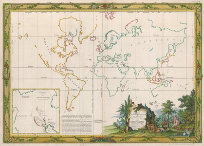
A rare and very large eighteenth century French map of the world, purporting to show the earth as it was in the two centuries following the Creation, published by the Jesuit Abbe Luneau. The map divides the world into the Old World and the New World, with the borders of each continent outlined in hand colour. Regional and national divisions do not yet exist in the map's setting, so the interiors of each landmass are left blank, though in Mesopotamia, the 'Paradis Terrestre' - the Garden of Eden - is shown. In the bottom left corner, a large inset map provides a supplementary map of the Holy Land, showing the various locations proposed for the location of Eden. Luneau obviously preferred a location beyond the union of the Tigris and Euphrates, now sunken into the Persian Gulf. In the bottom right corner, a very large dedicatory title cartouche is surrounded by an elaborate decorative vignette of the Garden itself, with Adam and Eve prominent in centre, with the Serpent coiled around the fatal Tree of Knowledge. Pierre-Joseph-François Luneau de Boisjermain (1731-1801), usually referred to as the Abbe Luneau, was a French Jesuit educator and polymath, best known for his successful legal battle with the editors and publishers of Diderot's Encyclopedie. Condition: Vertical and horizontal folds, as issued. Minor chips and creases to margins, not affecting map. Minor creasing to central folds. Blank on verso. |
| Framing | unmounted |
| Price | £900.00 |
| Stock ID | 52907 |

