
| Method | Steel engraved with original hand colour |
| Artist | Sagansan, L. |
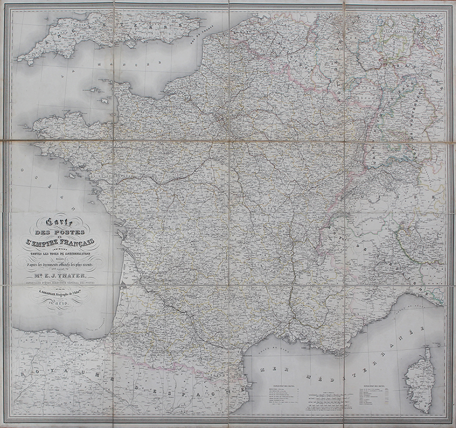
| Published | Par Ordre de Mr. E.J. Thayer, Conseiller d'État, Directeur Général des Postes par L. Sagansan, Géographe de l'Admon. Paris, 1853. |
| Dimensions | 1195 x 1255 mm |
| Notes |
A very large mid-nineteenth century folding map of France, issued in the first year of the Second Empire and the beginning of the newly proclaimed Emperor Napoleon III's grand vision for the overhauling of French industrial development. The map, sectioned into twelve sheets and laid to linen, shows the full extent of Metropolitan France, with national borders shaded in pink, and departmental divisions outlined in yellow. The borders of adjoining nations, including Spain, Belgium, Prussia, the Duchy of Baden-Wurtemberg, Switzerland, and the soon to be unified kingdoms and duchies of Italy are also shaded in hand colour. Nice, home of the Risorgimento hero Garibaldi, is shown as part of the Kingdom of Sardinia, which stretches as far east as the headland of La Spezia, from which a telegraph cable linking Corsica to the mainland was installed only a year after this map's production. The map in general is incredibly detailed, befitting a survey issued on behalf of the new administration. Particular attention is paid to the railways, a great personal interest of Napoleon III and a key developmental focus for his imperial ambitions. In the years following the map's publication, Napoleon III oversaw an program of railway building that was almost frenetic in its pace. Subsequent issues of this map show this, alongside canal and port infrastructure that by the end of Napoleon III's reign had transformed France into the second largest global maritime power, after its British rivals across the channel. Britain's own rail and port infrastructure is also partially mapped along the top left edge of the map, showing parts of England south of London and Bristol. L. Sagansan (fl.1853) was a French cartographer, who, after serving as geographer for the French Second Republic, was elevated to the position of Imperial Geographer under Emperor Napoleon III. Condition: Dissected and laid to linen, as issued. Minor time toning to linen folds, and associated creasing to edges of some sheets. Minor dirt staining from original adhesive along joints at centre. Some waterstaining to folds on verso, otherwise blank. |
| Framing | unmounted |
| Price | £400.00 |
| Stock ID | 52764 |