| Method | Copper engraved with hand colour |
| Artist | Ortelius, Abraham |
| Published | 1573. Ioannes a Deutecum f. Cum Privilegio. [Antwerp, 1602] |
| Dimensions | 350 x 495 mm |
| Notes |
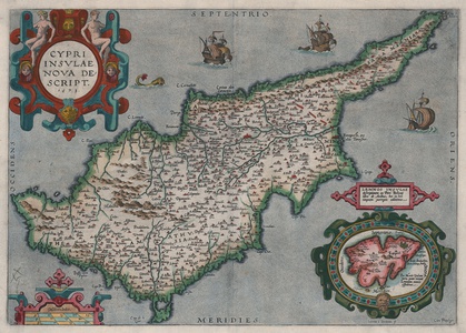
A beautiful sixteenth-century map of Cyprus, from the 1603 Latin edition of Ortelius' famous Theatrum Orbis Terrarum. The map is ornamented in beautiful hand colour, with the island's coasts, mountains, and rivers shown pictorially and cities and towns picked out in red. Nicosia is prominent at centre, as is Famagusta, the latter fed by three arcaded aqueducts. In the seas to the north and east of the island, sailing ships are shown, a testament to the island's long history of seafaring, while a sea monster also stalks the waters to the island's north. In the top left corner of the plate, the title is enclosed in an elaborate strapwork cartouche featuring a lion's mask and a pair of female nudes. A smaller strapwork box in the bottom left encloses a scale in Italian miles, a reminder of the island's historic ties to the Venetian republic. In the bottom right, an inset roundel encloses a map of the Greek island of Lemnos, drawn by Ortelius following a description by Petrus Belloni. The plate itself was originally engraved in 1573 by Joannes van Doetechum the Elder to replace an earlier composite plate of Cyprus and Crete, closely following the map of Cyprus produced by the Venetian geographer Giacomo Franco in 1570, the year of Ortelius' first edition of the Theatrum. The verso features a lengthy description in German of Cyprus and Lemnos. Abraham Ortelius (1527 -1598) was a Flemish cartographer, cosmographer, geographer and publisher and a contemporary of Gerard Mercator, with whom he travelled through Italy and France. Although it is Mercator who first used the word "Atlas" as a name for a collection of maps, it is Ortelius who is remembered as the creator of the first modern atlas. Theatrum Orbis Terrarum was the first systematically collated set of maps by different map makers in a uniform format. Three Latin editions as well as a Dutch, French and German edition of Theatrum Orbis Terrarum were published by 1572 and a further 25 editions printed before Ortelius' death in 1598. Several more were subsequently printed until around 1612. Ortelius is said to have been the first person to pose the question of the continents once being a single land mass before separating into their current positions. Condition: Central vertical fold as issued. Printer's crease to bottom left corner of sheet. Minor rubbing and dirt staining to margins. Manuscript signature or sigil in bottom left corner of map in old hand. German text on verso. |
| Framing | unmounted |
| Price | £1,750.00 |
| Stock ID | 52827 |

