
| Method | Copper engraving with hand colouring |
| Artist | Jan Jansson after Georg Braun and Frans Hogenberg |
| Published | [Amsterdam, c.1657] |
| Dimensions | Image and Plate 280 x 370 mm, Sheet 450 x 575 mm |
| Notes |
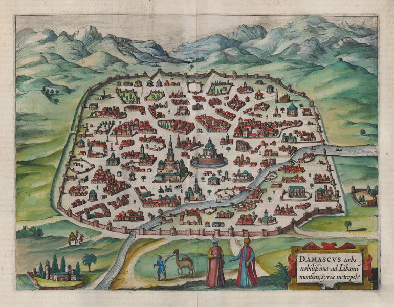
An aerial view of the city of Damascus, Syria, set against a background of mountains, from Jan Jansson's Theatrum Urbium. The current example is a very close copy of the late sixteenth century view of the City from volume two of Georg Braun and Frans Hogenberg's Civitates Orbis Terrarum. Although some of the original Braun and Hogenberg plates were reissued by Jansson for his city atlas, in this case the slight variations in size and spacing within the view point to this being a new plate, rather than simply a reworking of the old plate to accomodate Jansson's new title cartouche in the bottom right. The ancient city is shown inside its defensive walls, with the Umayyad mosques in the centre. The fine buildings, mosques, ruins, and gardens are plotted alongside Arab figures, camels, and palm trees in the foreground. On the verso, a lengthy descriptive text in Latin describes the long history of one of the world's oldest cities. Johannes Janssonius (1588-1664) was a famed cartographer and print publisher. More commonly known as Jan Jansson, he was born in Arnhem where his father, Jan Janszoon the Elder, was a bookseller and publisher. In 1612 he married the daughter of the cartographer and publisher Jodocus Hondius, and then set up in business in Amsterdam as a book publisher. In 1616 he published his first maps of France and Italy and from then onwards, produced a very large number of maps which went some way to rival those of the Blaeu family, who held a virtual monopoly over the industry. From about 1630 to 1638 he was in partnership with his brother-in-law, Henricus Hondius, issuing further editions of the Mercator/Hondius atlases to which his name was added. On the death of Hondius he took over the business, expanding the atlas still further, until eventually he published an eleven volume Atlas Major on a scale similar to Johannes Blaeu's magnum opus. After Jansson's death, his heirs published a number of maps in the Atlas Contractus of 1666, and, later still, many of the plates of his British maps were acquired by Pieter Schenk and Gerard Valck, who published them again in 1683 as separate maps. Between 1572 and 1617 Georg Braun (1541-1622) and Frans Hogenberg (1535-1590) published six volumes of their Civitates Orbis Terrarum, containing over 500 prospects, views, and maps of mostly European cities, envisioned as a companion to Ortelius' atlas Theatrum Orbis Terrarum. Braun was the editor of the series, with Hogenberg as principle engraver. They relied mainly on existing cartography, but also on drawings made by the Antwerp artist Joris Hoefnagel (1542-1600), who had travelled through most of Western Europe. After Joris Hoefnagel's death his son Jakob continued the work for the Civitates. Condition: Central vertical fold, as issued. Repaired tears to top and bottom of central fold. Minor time toning to edges of sheet. Latin letterpress text on verso. |
| Framing | unmounted |
| Price | £450.00 |
| Stock ID | 52841 |