| Method | Copper engraved with original hand colour |
| Artist | de Wit, Frederick |
| Published | Per F. de Wit Amstelodami cum Privilegio Potentiss. D.D. Ordinum Hollandiae, Westfrisiaeque. ex Officina P. Mortier [c.1700] |
| Dimensions | 500 x 575 mm |
| Notes |
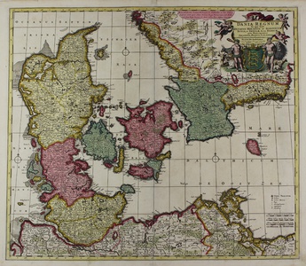
A large and impressive late seventeenth century map of the Kingdom of Denmark, with adjacent parts of southern Sweden and Northern Germany, from a Pierre Mortier printing of de Wit's Atlas Maior. The map is ornamented in beautiful original hand colour, with the various territories of the Danish kingdom washed in yellow, pink, and green. The map is centred on Zeelandia (Sjaelland), and Copenhagen more directly, here labelled as Koppenhaven. Shoals and sand banks are marked as patched of pointillism off various coasts, and three simple compasses roses are included on the map's gridded rhumblines. In the top right corner, the title is featured on a large cloth held aloft by winged cherubs, above the Danish Royal coat of arms supported by two rustic figures and a host of domestic animals. In the bottom right corner, Mortier has added, in addition to his publication line, a scale in German, Gallic, and Danish miles, as well as a key to the map's symbols for towns, farms, bishoprics and parishes, and academies. Frederick de Wit (1630-1706) was a Dutch geographer, and one of the most prolific and successful cartographic printers of the late seventeenth century, following the dominance of the Blaeu and Hondius publishing houses. His major achievement was his Atlas, which began appearing from around 1662, and continued in almost constant publication until the mid eighteenth century, first by de Wit himself, and after his death, by successors such as Ottens, Pierre Mortier, and Mortier's son Cornelis in partnership with Johannes Covens. Condition: Central vertical fold, as issued. Minor creasing to sheet. Minor time toning to margins, not affecting image. Blank on verso. |
| Framing | unmounted |
| Price | £600.00 |
| Stock ID | 45421 |

