
| Method | Woodcut |
| Artist | Fries, Lorenz after Waldseemüller, Martin |
| Published | [Melchior and Gaspar Trechsel, Lyon, 1535] |
| Dimensions | 295 x 460 mm |
| Notes |
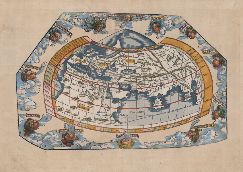
One of the earliest printed maps of the world, this particular example an excellent clean impression in full hand colour of the 1535 third edition of Lorenz Fries' reduced edition of Waldseemüller's 1513 woodcut Ptolemaic map of the Old World, printed by the Lyonnais publishers Melchior and Gaspar Trechsel. Cartographically the map is a close copy of Waldseemuller's map of the ancient world, which was itself based upon the earliest printed examples of Ptolemy's Geography, issued in Bologna (1477)and Ulm (1482). The map covers the three continents of the Old World, Africa, Asia, and Europe, in the distinctive chlamys (cloak) shape of Ptolemy's projection. Regions north of those known to the classical geographers are included in an extended triangle of the Mare Congelatum, the Sea of Ice. Along the extremities of the map's eastern edge, Asia is concluded by a secondary peninsula, the so-called 'Dragon's Tail,' though Fries does away with another common Ptolemaic feature, omitting the enclosing landmass linking southern Africa to southern Asia, enclosing the Indian ocean. Fries' first edition featured the title 'Generale Ptho.' in a ribbon cartouche at top, with the names of twelve classical winds written in the margins. Subsequent editions, as here, substituted a decorative woodcut border, featuring billows of cloud and characterful windheads. Fries' maps were published in four different editions, by Gruninger in Strasbourg in 1522 and 1525, and, following Fries' death in 1532, by Johann Trechsel in Lyon and Vienne in 1535 and 1541. The Trechsel editions featured text by the Spanish humanist, Michael Servetus, writing in this case under the name Villanovus. Unfortunately for Servetus, his theological treatises drew negative attention from Protestant and Catholic corners alike, and in 1553 he was found guilty of heresy and burned at the stake, and this put paid to any future editions of Fries' atlas. The woodcut borders on the versos of Gruninger and Trechsel's editions are traditionally attributed to Hans Holbein and Durer respectively. Lorenz Fries (c.1490-1532) was born in the Alsace region and studied variously at the universities in Pavia, Vienna, Piacenza and Montpellier. After completing his studies, Fries set himself up as a physician in Alsace, and briefly in Switzerland, before finally settling in Strasbourg in 1519, by which point he had published several medical texts. It was in Strasbourg that Fries meet Johann Gruniger, an associate of the St. Die group of scholars who included Martin Waldseemüller. From 1520 to 1525 Fries worked with Gruniger as his cartographic editor, producing numerous reduced woodblock maps using the vast material of Waldseemüller's 1513 Ptolemaic Atlas. Martin Waldseemüller (11th September, 1470 - 16th March, 1520) was a German author, cartographer, and publisher, and one of the most significant figures in the history of cartography. His most celebrated achievement was the publication in 1507 of his Universalis Cosmographia, a monumental twelve-panel map of the world making use of the discoveries of Columbus and Vespucci, and being the first recorded use of the title 'America' to describe the New World. In addition to this, Waldseemuller's appendix to his Ptolemaic atlas featured some of the very first individual maps of European discoveries in the New World, East Indies, and Western and Southern Africa. Ptolemy (c. AD 100-170) was a Greek native of the Egyptian city of Alexandria, and a Roman citizen. Little is known about his life, but he is credited as the author of numerous works of mathematics, engineering, astronomy, astrology, philosophy, and geography. His most famous works were the Almagest, the Geography, and the Tetrabiblion, a triad that essentially formed the basis of Byzantine, Arabic, and European science for the next thousand years. The Geography in particular had a very long reach, being reprinted numerous times in the fifteenth and sixteenth centuries. Its most famous advocate was Columbus, who used a manuscript of the Geography to plot his western course for Asia, in the journey that resulted in the discovery of America. The work was also a major inspiration, and cartographic resource, for Munster, Mercator, and Ortelius. Shirley 47 iii/iv Condition: Central vertical fold, as issued. Paper thinning and printers' creases to left margins, not affecting map. Light time toning from old mount to margins. Minor offsetting to top of block near centre fold. Blank on verso. |
| Framing | framed |
| Price | £4,000.00 |
| Stock ID | 52813 |