
| Method | |
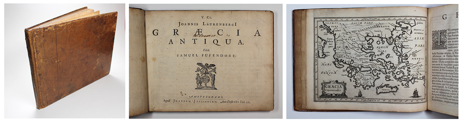
| Artist | Lauremberg, Johann |
| Published | Amstelodami, Apud Joannem Janssonium. Anno Christi MDCLX. [Amsterdam, 1660] |
| Dimensions | Oblong quarto (4°). 185 x 240 mm |
| Notes |
First edition. Contemporary calf boards, rebacked in 20th century brown calf. Title page with printer's device, iii, 62pp, 31 interleaved maps, i (Index of plates). Boards scuffed, old adhesive staining to front and back pastedowns, and forepage, manuscript owner's inscription to verso of forepage dated '1777,' annotation to verso of title, and minor ink staining to recto of title, repaired puncture to map of 'Creta Insula' without loss, minor marginal tears, folds, and time toning to some page edges, otherwise excellent clean example internally. The first printing of Lauremberg's Graecia Antiqua, one of the rarest early classical atlases, issued by Jan Jansson after the author's death with a suite of 31 beautifully engraved small scale maps of the regions of Greece in the classical period. Lauremberg's text, edited for publication by the German political philosopher and jurist Samuel Pufendorf, begins with a description of Greece as a whole and the region of Achaia, followed by a discussion of the Hellenised neighbouring kingdoms of Macedon and Epirus, before delving into outlines of each of the constituent parts of classical Greece, including many of the principal islands of the Aegean and Ionian, as well as city plans of Thebes, Corinth, and the countryside around Tempe and Mount Olympus. In addition to the interleaved maps that Jansson had engraved for each section of the atlas, a number of in-text illustrations are included, featuring representations of ancient coinage from many of the principal cities of antiquity, famous statuary, buildings, and scenery, as well as a charming schematic map of the Peloponnese in the shape of a fig leaf, with the Corinthian isthmus as its stem. Each chapter is further embellished with historiated initials and a decorative tailpiece. Lauremberg's commentaries, though not directly referencing his sources, evidently derives from an impressive knowledge of the classical corpus, making reference to events both historical and mythological in his treatment of each region. The maps themselves seem to have been commissioned for this atlas, though Jansson reused a number of them for later printings of his edition of the Mercator-Hondius Atlas Minor. A second printing of the Graecia Antiqua was issued in 1661. The atlas was not Jansson's first use of Lauremberg's cartography. Indeed Jansson's crediting of Lauremberg on a number of larger maps of Greece and its regions included in the Atlas Major before the latter's death in 1658 suggest the two were not infrequent collaborators. The full list of titles for the maps are as follows: Graecia Universalis, Achaia quae et Hellas, Macedonia, Epirus, Peloponnesus, Insulae Maris Aegaei, Attica, Megaris, Boeotia Superior, Boeotia Inferior, Thebae Boeoticae, Phocis, Corinthia et Sicyonia, Argia, Achaia Propria, Elis, Arcadia Superior, Arcadia Inferior, Laconicae pars Septentrionalis, Laconicae pars Meridionalis, Laconicae pars Orientalis, Messenia, Insulae Maris Ionii, Thracia, Creta Insula, Euboea Insula, Samus et Rhodus, Chius et Cia, Delus et Icaria Insulae, Tempe, Veteris Corinthi Ichnographia. Johannes Janssonius (1588-1664) was a famed cartographer and print publisher. More commonly known as Jan Jansson, he was born in Arnhem where his father, Jan Janszoon the Elder, was a bookseller and publisher. In 1612 he married the daughter of the cartographer and publisher Jodocus Hondius, and then set up in business in Amsterdam as a book publisher. In 1616 he published his first maps of France and Italy and from then onwards, produced a very large number of maps which went some way to rival those of the Blaeu family, who held a virtual monopoly over the industry. From about 1630 to 1638 he was in partnership with his brother-in-law, Henricus Hondius, issuing further editions of the Mercator/Hondius atlases to which his name was added. On the death of Hondius he took over the business, expanding the atlas still further, until eventually he published an eleven volume Atlas Major on a scale similar to Johannes Blaeu's magnum opus. After Jansson's death, his heirs published a number of maps in the Atlas Contractus of 1666, and, later still, many of the plates of his British maps were acquired by Pieter Schenk and Gerard Valck, who published them again in 1683 as separate maps. Johann Lauremberg (1590-1658), often erroneously transcribed as 'Laurenberg,' was a German poet, author, satirist, mapmaker, and mathematician, active in Rostock, Reims, Paris, and Zealand. In addition to his academic and literary career, Lauremberg also travelled widely in the Netherlands, France, Italy, and England. |
| Framing | |
| Price | £4,750.00 |
| Stock ID | 53182 |