
| Method | Copper engraved with hand colour |
| Artist | Hondius, Henricus |
| Published | Amstelodami ex officina Henrici Hondii. A°1631 [Amsterdam, 1637] |
| Dimensions | 370 x 495 mm |
| Notes |
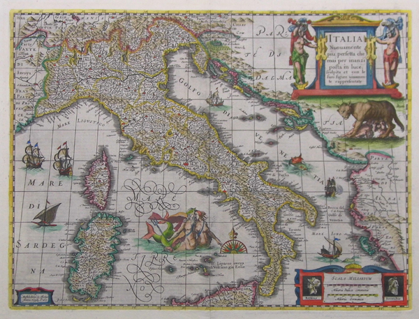
One of the most richly decorated early maps of Italy, this example from the first and only English printing of the Mercator-Hondius Atlas. The map shows the whole of Italy, as well as Corsica, Sardinia, the northern part of Sicily, and adjoining parts of France, Switzerland, Germany, Dalmatia, and Albania, with regional and national boundaries outlined in hand colour. Principal cities are picked out in red, and mountains, lakes, and forests are shown pictorially. In addition to this, the map is highly ornamented with sailing ships and sea monsters in the Sardinian, Tyrrhenian, and Adriatic Seas. A merman and merwoman are locked in an embrace above the Aeolian islands, and a large vignette to the right of the map shows part of the foundational myth of the city of Rome with the twin infants Romulus and Remus being suckled by the shewolf. The map is further embellished by a large title cartouche in Italian, flanked by two bare-breasted caryatids, while the mile scale in the bottom right features portrait roundels of the twins as adults. On the verso, a lengthy descriptive text in English written by the soldier, translator, and author Henry Hexham (c.1585-1650) covers Italian customs, dress, geography, government, and architecture. Hexham's commentary also contains a long list of the natures of women from various Italian cities and towns, and criticisms of the ostentation and lack of humility shown by the Pope and the Roman church. Henricus Hondius (1597 - 16th August 1651), often called Henrik Hondius the Younger to differentiate him from the earlier, and unrelated portrait engraver Hendrik Hondius the Elder, was the son of the famous cartographer Jodocus Hondius. Like his father, Henricus was an engraver, cartographer, and publisher. He first came to prominence through his publication in 1606 of a new version of Mercator's 1569 World Map, the plates for which he had obtained from Mercator's grandson Rumold. Following his father's death, Henricus co-ran the family business, eventually partnering with his brother-in-law, Jan Jansson. Johannes Janssonius (1588 - 1664) was a famed cartographer and print publisher. More commonly known as Jan Jansson, he was born in Arnhem where his father, Jan Janszoon the Elder, was a bookseller and publisher. In 1612 he married the daughter of the cartographer and publisher Jodocus Hondius, and then set up in business in Amsterdam as a book publisher. In 1616 he published his first maps of France and Italy and from then onwards, produced a very large number of maps which went some way to rival those of the Blaeu family, who held a virtual monopoly over the industry. From about 1630 to 1638 he was in partnership with his brother-in-law, Henricus Hondius, issuing further editions of the Mercator/Hondius atlases to which his name was added. On the death of Hondius he took over the business, expanding the atlas still further, until eventually he published an eleven volume Atlas Major on a scale similar to Johannes Blaeu's magnum opus. After Jansson's death, his heirs published a number of maps in the Atlas Contractus of 1666, and, later still, many of the plates of his British maps were acquired by Pieter Schenk and Gerard Valck, who published them again in 1683 as separate maps. Gerard Mercator (1512 - 1594) originally a student of philosophy was one of the most renowned cosmographers and geographers of the 16th century, as well as an accomplished scientific instrument maker. He is most famous for introducing Mercators Projection, a system which allowed navigators to plot the same constant compass bearing on a flat map. His first maps were published in 1537 (Palestine), and 1538 (a map of the world), although his main occupation at this time was globe-making. He later moved to Duisburg, in Germany, where he produced his outstanding wall maps of Europe and of Britain. In 1569 he published his masterpiece, the twenty-one-sheet map of the world, constructed on Mercator's projection. His Atlas, sive Cosmographicae Meditationes de Fabrica Mundi, was completed by his son Rumold and published in 1595. After Rumold's death in 1599, the plates for the atlas were published by Gerard Jr. Following his death in 1604, the printing stock was bought at auction by Jodocus Hondius, and re-issued well into the seventeenth century. Jodocus Hondius (14th October 1563 - 12th February 1612) was a Dutch Flemish cartographer, engraver, and publisher. Hondius is most famous for reviving the primacy of the work of Gerard Mercator, through the publication of his Atlas, and the smaller Atlas Minor, in the early seventeenth century, at a time when cartography was largely dominated by Ortelius' Theatrum Orbis Terrarum. The Mercator-Hondius Atlas was composed of maps pulled from plates Hondius had purchased from Mercator's grandson, as well as thirty-six new plates Hondius commissioned, and in many cases engraved, himself. He is also believed to have been the chief engraver of the plates for John Speed's Theatre of the Empire of Great Britaine. Following his death, he was succeeded by his sons, Jodocus the Younger and Henricus, as well as his son in law Jan Jansson. Condition: Central vertical fold, as issued. Minor acid burn from old mount to margins, not affecting plate. Chip to bottom right corner of sheet. English text on verso. |
| Framing | unmounted |
| Price | £1,500.00 |
| Stock ID | 35748 |