| Method | Copper engraved with hand colour |
| Artist | Kitchin, Thomas |
| Published | Printed for R. and I. Dodsley in Pall Mall. [1764] |
| Dimensions | 337 x 335 mm |
| Notes |
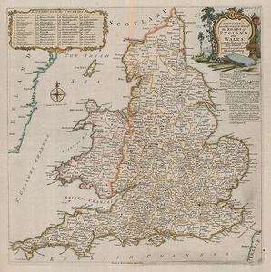
An eighteenth century road map of England and Wales, with adjacent boarders of Scotland, the east coast of Ireland, and northern France. Decorative title cartouche in the upper right, counties are marked on the map with numbers with an inset key within a decorative boarder in the upper left. Counties are indicated with dotted lines, outline colour, and a number which refer to the inset key. Towns and villages are labelled and the number of miles between them. This map was first issued in 1763 in the London Magazine. This example comes from R. & J. Dodsley's 1764 book England Illustrated. Thomas Kitchin (1718-1784) was one of the best and most prolific engravers of the eighteenth century. He issued The General Atlas, Describing the Whole Universe, first published in 1773, and regularly reissued thereafter. His work also included a large number of maps of the English counties, particularly for the London Magazine (1747-1760), the Universal Magazine (1747-1766), and for Dodsley's England Illustrated (1764). Other maps were published in conjunction with Emanuel Bowen in the Large English Atlas and the Royal English Atlas (1763). Condition: Horizontal and vertical folds as issued. |
| Framing | unmounted |
| Price | £200.00 |
| Stock ID | 53108 |

