| Method | Copper engraved with early hand colour |
| Artist | de l'Isle, Guillaume |
| Published | Par G. de L'Isle Geographe de l'Academie Royale des Sciences, A Paris Chez l'Auteur Rue des Canettes prez de St. Sulpice, Avec Privilege du Roy pour 20 ans. Grave par J.B. Liebaux 1702. |
| Dimensions | 475 x 620 mm |
| Notes |
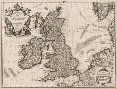
The first state printing of De l'Isle's celebrated and much copied early eighteenth century French map of the British Isles, engraved by Jean Baptiste Liebaux in 1702. The map shows the whole of the British Isles, as well as neighbouring parts of France, Belgium (here called the Spanish Netherlands), the Netherlands, Denmark, and Norway. Coasts and provincial borders are outlined in hand colour, and sand banks in the North Sea are shown as dotted patches. In the bottom right, a baroque cartouche encloses a mile scale, while a much larger decorative cartouche in the top left surrounds the title, featuring vignettes alluding to Britain's maritime power, with Neptune and a team of Tritons calming a pair of hippocamps. Guillaume de l'Isle (1625 - 1726) was one of the finest cartographers of the eighteenth-century. He is widely regarded as the father of scientific mapmaking, and was the first to utilise the practices of triangulation and mensuration in the production of his works. Condition: Central vertical fold, as issued. Minor time toning to edges of sheet. Manuscript '8' to top right corner of sheet in old hand. Small wormholes to left and right edges of map. Blank on verso. |
| Framing | unmounted |
| Price | £800.00 |
| Stock ID | 52863 |

