| Method | Copper engraved with early hand colour |
| Artist | Elwe, Jan Barend |
| Published | Compose selon les plus Nouvelle Observations des meilleurs Geographes, Publiee par Ian Bt. Elwe, a Amsterdam MDCCXCII [Amsterdam, 1792] |
| Dimensions | 475 x 595 mm |
| Notes |
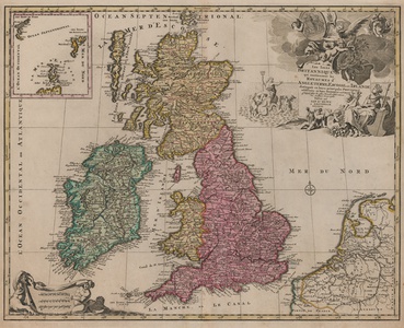
A late eighteenth century French map of the British Isles, from Jan Barend Elwe's rare Atlas. The map shows England, Wales, Scotland, and Ireland divided into their provinces, shires, and counties, with national and regional borders outlined in hand colour. London, Oxford, York, Edinburgh, and Dublin are picked out in red, and an inset boxed map to top left shows the Faro and Shetland Isles. The western coasts of France, Flanders, and the Netherlands are also shown, and a simple compass rose is included in the North Sea. In the top right, the title is enclosed by a large and very decorative figural cartouche, featuring symbols of the British Isles' wealth and maritime power. In the bottom left, a trio of tritons raise a banner containing a mile scale. Jan Barend Elwe (fl.1792) was a Dutch bookseller and cartographer, primarily known for his Atlas. Despite carrying his imprimatur, the majority of maps from the Atlas were actually reissues of maps by other mapmakers, especially de l'Isle, Sanson, and Ottens. Condition: Central vertical fold, as issued. Creasing to sheet. Blank on verso. |
| Framing | unmounted |
| Price | £500.00 |
| Stock ID | 52861 |

