
| Method | Paniconograph |
| Artist | Ettling, Theodore |
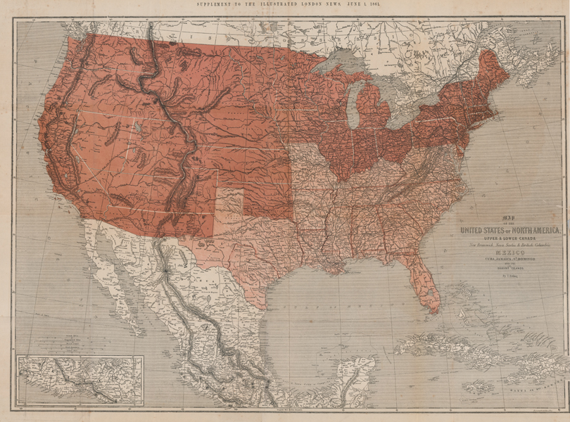
| Published | Paniconographie de Gillot, a Paris. Supplement to the Illustrated London News, June 1, 1861. |
| Dimensions | 680 x 930 mm |
| Notes |
A large folding map of North America issued by the Illustrated London News at the beginning of June 1861, less than two months after the outbreak of the American Civil War. The map divides the US into Free States, marked in red, and Slave States, marked in pink, providing the mainly British audience of the Illustrated London News with a visual representation of the divisions within the country at the time of Lincoln's election to president in 1860. By the time of printing, Jefferson Davis and the Confederate government had hoped that the secessionist cause would be supported by Britain and France, particularly when the supply of American cotton ceased, causing mass unemployment in Lancashire. Despite this, both Britain and France remained officially neutral throughout the conflict, with many mills in Manchester refusing to process American cotton on moral grounds. The map takes a Unionist view of the status of New Mexico, Arizona, and the Indian Territory (modern Oklahoma) by including them as Free States. Confederate states argued that the Constitution allowed the expansion of slavery into these areas. The map also predates the creation of West Virginia, which was created in 1863 after loyalist counties split from the Confederate counties that made up the rest of Virginia. Proposed railways are also shown as double lines crisscrossing the country, preempting the passing in 1862 of the Pacific Railroad Acts, intended by Lincoln and the Unionist government to better connect the western states with the federal seats of power in the east. In addition to the United States, the map also shows Mexico with the southern parts of the country included in an inset map in the bottom left, the northern islands of the Caribbean, and British possessions in southern Canada. The map was printed using a relatively new technology at the time, called a paniconograph by its creator Firman Gillot. The process used photoengraving to produce a relief plate similar to a woodcut. Theodore Ettling (1823-1862) was a German-born engraver, lithographer, and mapmaker. After working for Jacob Swart in Amsterdam, he emigrated to London, where he produced maps for the Dispatch Atlas. Condition: Vertical and horizontal folds, as issued. Minor creasing, foxing, and splitting to folds. Trimmed to neatline at bottom half of right edge of sheet, as issued. Blindstamp for 'Bristol Public Library' at top left of sheet. |
| Framing | unmounted |
| Price | £375.00 |
| Stock ID | 52812 |