| Method | Chromolithograph |
| Artist | Johnston, William and Johnston, Alexander Keith |
| Published | Engraved & Printed by W. & A.K. Johnston, Edinburgh. [c. 1890] |
| Dimensions | 570 x 438 mm |
| Notes |
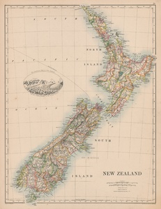
A large late nineteenth century map of New Zealand from the 1884 printing of Johnston's Royal Atlas of Modern Geography. The country is divided into regions and districts, with each picked out in colour. An oval vignette in the South Pacific shows 'The Southern Alps of New Zealand, from the Central Moraine of the Godley Glacier.' A thin line beginning in Tasman Bay and running through the South Pacific marks the undersea telegraph line between Nelson and Sydney that was laid in 1875. On the verso, a map of the continent of Africa is shown, with states, nations, and colonial holdings outlined in hand colour. Alexander Keith Johnston (1804 - 1871) was a Scottish geographer who was the first to bring the study of physical geography into competent notice in England. His son Alexander Keith Johnston (1844-1879) was also the author of various geographical works and papers. W. & A.K. Johnston was one of the major publishing houses of the 19th century. Founded by William and Alexander Keith (1804-1871) Johnston, they apprenticed under the Scottish publisher and globe maker James Kirkwood in Edinburgh. They later went on to establish their own business in the city, expanding their output into not only maps, but atlases, guide books, globes and educational posters. Alexander's son, also called Alexander Keith Johnston (1844-1879), continued the business, as well as authoring various geographical works of his own. The business continued to publish material under the Johnston name until the 1960s. Condition: Minor time toning to sheet. |
| Framing | unmounted |
| Price | £150.00 |
| Stock ID | 52022 |

