
| Method | Copper engraved with hand colour |
| Artist | Jansson, Jan |
| Published | Amstelodami, apud Ioannem Ianssonium [Amsterdam, c.1640] |
| Dimensions | 415 x 530 mm |
| Notes |
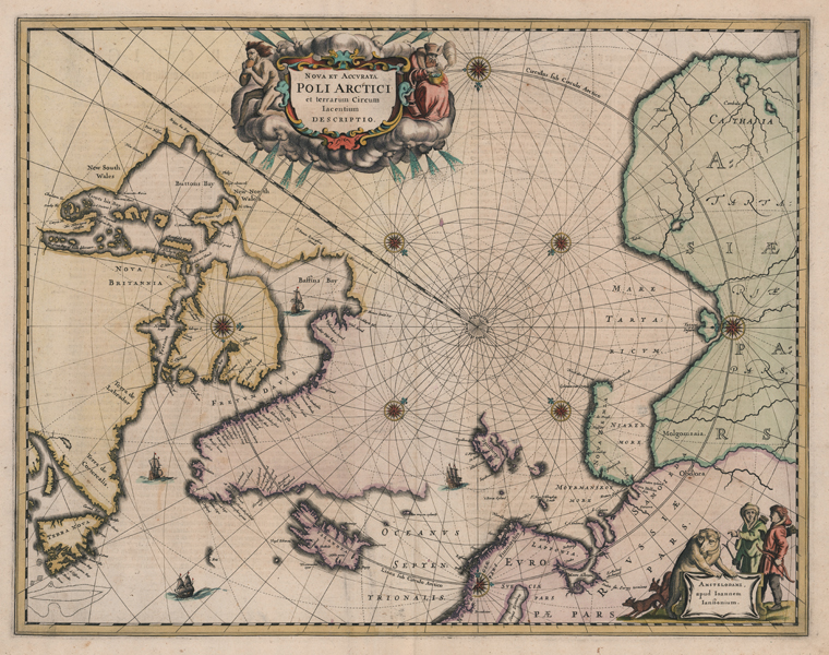
A fine seventeenth century map of the Arctic Circle, the second of the region engraved by Jansson, from a Dutch edition of his Atlas Novus. The map is centred on the North Pole, with rhumb lines and compass roses converging on an empty space in the Arctic Sea. Coastlines and putative coastlines are outlined in early hand colour, representing the Polar north of Asia, Europe, and North America. Partial coasts of Novaya Zemlya and Spitsbergen (Svalbard) are shown, and Greenland is shown joined to Canada, largely ruling out the possibility of a Northwest Passage, though broken sections at the northern reaches of Baffin's Bay leave the coastline undetermined. Much of Hudson Bay is here referred to as Buttons Bay, in reference to the 1612 expedition of Welshman Thomas Button, who founded an encampment at Fort Nelson. The region of modern Nunavik still retains the earlier titles of New North Wales and New South Wales, given in 1631 by Thomas James and Luke Foxe in honour of Button. An area off the coast of Newfoundland marked with dotted lines is likely a reference to the cod fisheries that drew European settlers to the region. In the seas between Iceland and Labrador, two ships sail, while a third is shown in Baffin's Bay. In the centre top, a large decorative title cartouche features icy windheads, supported by a naked Hyperborean and a stooped old man in furs. In the bottom right, the imprimatur is flanked by a pair of Samoyedic hunters, a bear, and two foxes. Johannes Janssonius (1588 - 1664) was a famed cartographer and print publisher. More commonly known as Jan Jansson, he was born in Arnhem where his father, Jan Janszoon the Elder, was a bookseller and publisher. In 1612 he married the daughter of the cartographer and publisher Jodocus Hondius, and then set up in business in Amsterdam as a book publisher. In 1616 he published his first maps of France and Italy and from then onwards, produced a very large number of maps which went some way to rival those of the Blaeu family, who held a virtual monopoly over the industry. From about 1630 to 1638 he was in partnership with his brother-in-law, Henricus Hondius, issuing further editions of the Mercator/Hondius atlases to which his name was added. On the death of Hondius he took over the business, expanding the atlas still further, until eventually he published an eleven volume Atlas Major on a scale similar to Johannes Blaeu's magnum opus. After Jansson's death, his heirs published a number of maps in the Atlas Contractus of 1666, and, later still, many of the plates of his British maps were acquired by Pieter Schenk and Gerard Valck, who published them again in 1683 as separate maps. Condition: Central vertical fold, as issued. Minor creasing and tears to margins, not affecting map. Dutch text on verso. |
| Framing | unmounted |
| Price | £1,100.00 |
| Stock ID | 52798 |