
| Method | Copper engraved with early hand colour |
| Artist | Plancius, Petrus |
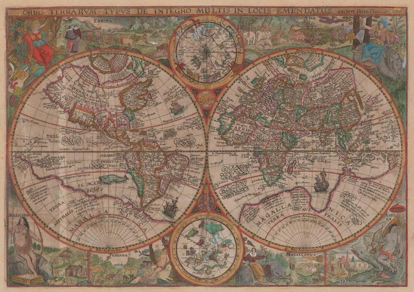
| Published | auctore Petro Plancio 1594. Ioannes a Duetecum iunior fecit [Amsterdam, c.1599] |
| Dimensions | 410 x 580 mm |
| Notes |
Plancius' double hemisphere world map, a landmark example of early decorative map making, from Jan Huygen van Linschoten's celebrated Itinerario, one of the most influential travel narratives of the Dutch golden age. Originally issued separately by Plancius in 1594, from 1599 onwards it was issued, as here, as a folding map in Linschoten's voyages. The first world map to feature decorative personifications of the continents in its borders, Plancius' map was hugely influential, setting the standard for ornamentation for northern European world maps for the next century. Engraved by the younger Joannes van Doetechum, the border decorations were closely based upon illustrations from de Bry's Voyages, the first volume of which had appeared in 1590 to immediate acclaim from academic circles across Europe. Cartographically, the map is modelled closely on Plancius' earlier world map of 1590, though with improvements made to the mapping of Korea and Japan particularly, with the former shown correctly as a peninsula and the latter having a much more detailed coastline likely inspired by the charts of the Portuguese cartographer Luiz Teixeira, which came to prominence a year later in 1595 with the publication of Ortelius' first map of Japan. In the Arctic, Plancius has retained Mercator's distinctive set of four polar islands surrounding a polar sea, though the putative mountain at the pole itself is absent. Much of the southern half of each hemisphere is dominated from the huge landmass of Magellanica, Terra Australis, which, following Augustine of Hippo, was often suggested as a counterweight to the continents of the northern hemisphere. Much of what would later be identified as the northern coastline of Australia is here presented as Java Minor, preserving a number of placenames originally deriving from Marco Polo, including Beach, Locach, and Maletur. The map is further embellished with sailing ships and a large sea monster off the western coast of South America, and national and regional boundaries are outlined in hand colour. In the spaces between the terrestrial hemispheres are two smaller roundels showing the constellations of the northern and southern hemispheres, based upon a celestial globe Plancius published in collaboration with Jacob van Langren. Many of the gaps remaining in the mapping of the southern constellations were named and charted through the support of Plancius in the years following the publication of this map, through his training of the Dutch pilot and cartographer Pieter Dirkszoon Keyser. The remaining decoration on the map is a grand example of the European world view at a critical moment in the expansion of colonial power. Europa is personified as Queen of Nations in the top left, seated on a throne atop an orb, with the symbols of her achievements at her feet: arms and armour, a lute, an armillary sphere, a caduceus, and a cornucopia. Behind her is a vignette of trade, war, and agriculture. In the top right, Asia, in silks, sits upon a rhinoceros, a flaming censer in one hand and a box of gold at her feet. Behind her, exotic animals parade near an army of clashing horsemen. The remaining four nations are given half vignettes along the bottom margin. Mexicana, representing the northern half of the Americas, is seated upon a massive armadillo, wearing a grass skirt and carrying a long bow. Next to her, Peruana (Peru) is shown as a figure on a leopard wearing a feathered headress, with a scene of cannibalism in the background. Magellanica, the least well known of the nations depicted, is purely speculative, with an elegant figure in European dress shown riding a crouched elephant, while an army behind ride more elephants below a long tailed animal most likely intended to represent a bird of paradise. Finally, Africa, in the bottom right, sits astride a grinning crocodile, with the very stylized Egyptian pyramids visible in the distance. Pieter Platevoet, known by his latinised nom-de-plume Petrus Plancius, (1552-1622) was a Flemish theologian, astronomer, and cartographer. Having fled to Amsterdam to avoid the Inquisition, Plancius became aquainted with many of the most significant geographers and navigators of his era, including the English navigator Henry Hudson, the author van Linschoten, the astronomers Keyser and de Houtman, and the mapmakers Hondius the Elder and Pieter van den Keere. In addition to creating one of the Dutch Golden Era's most decorative and significant world maps, Plancius was also involved in the foundation of the Dutch East India Company and contributed to the mapping and naming of numerous constellations in the southern hemisphere. Joannes van Doetechum the Younger (fl.1587-1630) was a Dutch engraver and publisher, and a member of the van Doetechum family of printmakers. The son of Joannes van Doetechum the Elder (1530-1605), he was trained alongside his brothers Baptista and Peter by his father and his uncle, Lucas. Active in Amsterdam, Haarlem, and Deventer, he is best known for engraving plates for Linschoten's Itinerario. Jan Huygen van Linschoten (1563-1611) was a Dutch adventurer, author, and merchant, best known for his role in breaking the Portuguese monopoly in the East Indies through his publication of formerly secret navigational and trade information. Born in Haarlem and raised in Enkhuizen, Linschoten left his native Holland for Spain when young, seeking a mercantile career alongside his older brothers in Spain. Following the Spanish occupation of Portugal, he took a position in the colony of Goa, where he documented local life and, crucially, gained access to Portuguese documents, which he copied and published upon his return to Amsterdam. His cooperation with the publisher Cornelis Claesz led to the production of illustrated narratives of the Barentz voyages, his time in the East Indies, and, most famously, the Itinerario, which was republished multiple times in Dutch, Latin, English, German, and French for almost half a century. Shirley 187 Condition: Vertical and horizontal folds, as issued. Trimmed to neatline as issued, now remargined and backed with archival tissue. Time toning, creasing, and surface dirt to sheet. Repaired tears and splitting to folds, with small patches of infilling to top right corner and fold lines in the 'Circulus Antarcticus' to left and right. Adhesive staining to margins. Blank on verso. |
| Framing | mounted |
| Price | £12,000.00 |
| Stock ID | 52816 |