| Method | Copper engraved with hand colour |
| Artist | Hole, William after Saxton, Christopher |
| Published | Christophorus Saxton descripsit, Gulielmus Hole Sculp. [London, 1637] |
| Dimensions | 272 x 291 mm |
| Notes |
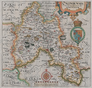
A third impression of this important, detailed county map of Oxfordshire from William Camden's 'Britannia', ornamented in beautiful hand colour. Based on the survey of Christopher Saxton, William Hole's elaborately decorated county map includes the arms of James I, a decorative strap work title cartouche, and fleur-de-lis adorned compass rose above a scale of miles. William Camden's great Renaissance work 'Britannia' was originally published in Latin, in 1586 with only a general map, providing a historical and topographical study of Great Britain. His stated intention was to "restore antiquity to Britaine, and Britain to his antiquity". Its popularity lead to numerous further editions in the late 16th century, with the 1607 printing the first to include a complete set of county maps and the last one to be published in his lifetime. The maps were mainly based on the surveys of Christopher Saxton and John Norden, and the engraving was shared between William Kip and William Hole. The maps were distinctively engraved, Hole's flamboyant style contrasting with the more formal calligraphy of his colleague. The 1607 edition was unique in that the maps were published with Latin text on the reverse. Saxton's habit of combining several counties into one map resulted in the 1607 printing of 'Britannia' gaining importance as it included the first separately printed representations of many of the English and Welsh counties. Three editions of the Kip and Hole maps may be found. The first is identifiable by Latin verso text (1607), the second (1610) lacks text, while the third (1637) displays an engraved plate number. William Hole (active 1600-1624) was a skilled English engraver active in the seventeenth century. Best-known for producing maps for Camden's 'Britannia', Hole also engraved portraits, music scores, frontispieces and topographical scenes. Christopher Saxton (c.1540 - c.1610) was a British estate surveyor and draughtsman, best known for his maps of English counties. Apprenticed to the cleric and cartographer John Rudd, Saxton developed the skills to become the man now known as 'the father of English cartography'. Under the patronage of Thomas Seckford, Saxton carried out an extensive topographical survey of England and Wales during the years 1573-1578. 34 county maps based on the surveys were engraved between 1574 and 1578 by Remy Hogenberg, Lenaert Terwoort, Cornelis de Hooghe, Augustine Ryther, Francis Scatte, and Nicholas Reynolds, forming the first atlas of England and Wales. The work was the basis for many later maps. The maps were issued by Saxton in untitled volumes from 1579, and subsequently reissued as The Shires of England and Wales, by William Web in 1645, by Philip Lea (with added maps) and in a French edition Atlas Anglois in 1693, by G Willdey in 1732, by T Jefferys in 1749, and finally as a wall map of England and Wales in 20 Sheets in c. 1770. Condition: Central vertical fold as issued. Minor surface creasing. Armorial watermark to left side of sheet. Blank on verso. |
| Framing | mounted |
| Price | £575.00 |
| Stock ID | 53094 |

