| Method | Copper engraved with early hand colour |
| Artist | Blaeu, Johannes |
| Published | Auctore Guilielmo Blaeu. [Joh. Blaeu, Amsterdam, c.1645] |
| Dimensions | 410 x 530 mm |
| Notes |
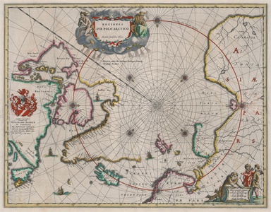
Johannes Blaeu's celebrated and highly sought after map of the northern polar regions, beautifully ornamented in early hand colour. The map is credited to his father William Janzoon Blaeu, and provides what was at the time the most up to date map of the Arctic circle and surrounding territories, following discoveries and cartographic advances in the Davis Strait, Hudson Bay, Baffins Bay, Buttons Bay, James' Bay (named for Thomas James of Bristol who explored the coast in 1631-2),Svalbard (Spitsbergen), Nova Zembla, and others. Greenland is shown joined to what is now Canada, largely ruling out the possibility of a Northwest Passage, though broken sections at the northern reaches of Baffin's Bay leave the coastline undetermined. Iceland, though elongated, is clearly recognisable. Much of Hudson Bay is here referred to as Buttons Bay, in reference to the 1612 expedition of Welshman Thomas Button, who founded an encampment at Fort Nelson. The region of modern Nunavik still retains the earlier titles of New North Wales and New South Wales, given in 1631 by Thomas James and Luke Foxe in honour of Button. An area off the coast of Newfoundland marked with dotted lines is likely a reference to the cod fisheries that drew European settlers to the region. Earlier models for Polar mountains, islands, sinkholes, or lakes are here excluded in favour of a large blank area at the actual pole, decorated instead with intersecting rhumb lines from eight compass roses. The map also features a number of sailing ships, a dedicatory crest for William Backer, consul of Amsterdam, and a pair of decorative cartouches. The title is flanked by a pair of figures, a pale and emaciated Hyperborean figure representing Hunger (Fames) and an elderly stooped figure in heavy cloaks personifying Cold (Frigus). In the bottom right corner, the scale is surrounded by a pair of foxes, a polar bear, and two hunters, likely intended to represent a Samoyed and a Tartar. The Blaeu family were one of the most famous publishers of maps, globes and atlases during the seventeenth-century. Cartographers, globe makers and booksellers, the Blaeu business flourished in Amsterdam for over 40 years, until a fire destroyed their premises in 1672. They lost all of their plates, prints and stock, which effectively ruined the firm. Willem Janzoon Blaeu (1571-1638) founded the family business in 1596. It initially functioned as a globe and instrument makers, but soon expanded into maps, topography and sea charts. The acquisition of thirty-eight copper plates from the estate of Jodocus Hondius in 162 together with twenty-two of his own maps enabled Blaeu to produce his first atlas, the 'Atlas Appendix' in 1630. The Atlas Novus was Willems great work; a major work which intended to include the most up-to-date maps of the entire world. He issued the first two volumes in 1635, but died in 1638 before the atlas was completed. The running of the business was passed on to his sons Johannes (c.1596-1673) and Cornelius, in addition to the role of the official cartographer of the East India Company. After the death of Cornelius in 1644, Johannes continued the business alone and established his own reputation as a great mapmaker. Johannes completed his father's grand project, culminating in 1658 in the production of the famous 'Atlas Major', regarded as one of the greatest achievements in the history of cartography. The county maps of England and Wales formed volume four of Blaeu's great atlas, this volume being first published in 1645 and re-issued without any alterations in 1662 as the fifth volume instead of the fourth. Condition: Central vertical fold, as issued. Clean, crisp impression with full margins. Minor offsetting from old red hand colour. Minor verdigris to verso. Latin text on verso. |
| Framing | unmounted |
| Price | £1,750.00 |
| Stock ID | 52828 |

