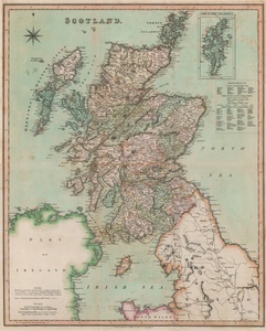
| Method | Steel engraved with early hand colour |
| Artist | Teesdale, Henry |
| Published | London. Published by Henry Teesdale & Co. 302 Holborn [London, c.1829] |
| Dimensions | 645 x 525 mm |
| Notes |
A large and uncommon nineteenth century map of Scotland, published by Henry Teesdale in his New British Atlas. The map is ornamented in full early hand colour, with county and national borders outlined. In the top right, an inset boxed map shows the Shetland Islands, and indices in the top right and bottom left provide information about parliamentary representation, and the roads and mail coaches across the country. Henry Teesdale (1776-1856) was a British cartographer and atlas publisher, and a fellow of the Royal Geographical Society. In the latter part of his career, following the 1832 publication of his Improved New British Atlas, Teesdale collaborated with a number of the other leading British map makers of the era, including Dower and Greenwood. Condition: Horizontal and vertical folds, as issued. Minor time toning and surface dirt. Blank on verso. |
| Framing | unmounted |
| Price | £300.00 |
| Stock ID | 52906 |

