
| Method | Steel engraved |
| Artist | Rapkin, John |
| Published | The London Publishing and Printing Company [c.1851] |
| Dimensions | 244 x 321 mm |
| Notes |
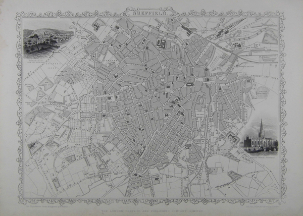
A plan of Sheffield, featuring a vignette of the city from the south east, and another of the parish church. Tallis maps were highly valued for their accuracy, but perhaps more so for their charming vignettes and ornamentation. Engraved by John Rapkin, these maps were praised by the New York Sun as "the most accurate and most splendid publication of the kind ever issued". The Bristol Times observed that Mr. Tallis maps "are not only critically correct, but are accompanied with elegant and appropriate engravings illustrative of the manners and costumes of the different countries." One of the most popular cartographers of the 19th Century was John Tallis, a London publisher. Tallis was renowned for the very accurate and visually most attractive maps and views of all world areas during the Victorian Age. His star engraver and map maker was John Rapkin. During the mid 19th Century many books of travel and exploration were published by Tallis, using the extraordinary artistic and engraving skills of John Rapkin. In 1851 Tallis published his famous Illustrated Atlas. The principal features of Tallis maps are the extensive use of vignette views and highly ornamental engraved framing of the perimeter. Most of his maps contained a limited amount of color, usually outlining boundaries and major terrain features. Later in the Nineteenth Century, many owners of Tallis atlases commissioned colorists to tint the beautiful vignettes. John Tallis and Company published views, maps and Atlases in London from 1838 to 1851. They expanded on the earlier works of Cary and Arrowsmith. John Rapkin was the principle engraver. The London Printing and publishing Company of London and New York bought the rights for many Tallis maps in 1850 and continued Publishing his Illustrated Atlas of the World until the mid 1850s. John Rapkin was an engraver and mapmaker active in Britain in the mid-nineteenth century. He drew and engraved the maps for John Tallis' The Illustrated Atlas and Modern History of the World (1845-51), which was later re-issued by the London Printing and Publishing Company. He also drew and engraved maps for R. Montgomery Martin's British Colonies, their history (1849), and Wright's Universal Pronouncing Dictionary (c.1850). Condition: Some light discolouration to sheet. |
| Framing | unmounted |
| Price | £140.00 |
| Stock ID | 39585 |