
| Method | Chromolithograph |
| Artist | [Anonymous] |
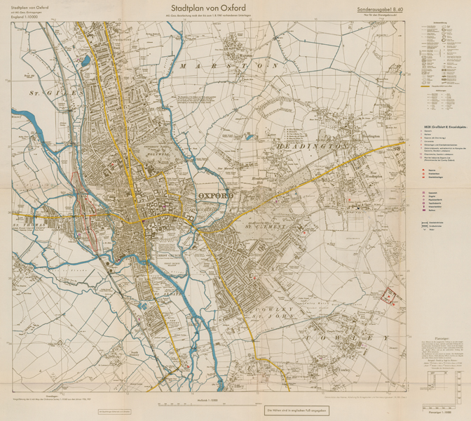
| Published | Generalstab des Heeres. Abteilung fur Kriegskarten und Vermessungswesen (IV. -Mil.-Geo.) Sonderausgabe! 8.40 [c.1941] |
| Dimensions | 625 x 710 mm |
| Notes |
A wartime map of Oxford, issued for the General Staff of the Army by the Mapping and Surveying Department of the Nazi regime, in the months following the failure of the Luftwaffe to deliver victory during the Battle of Britain and The Blitz. The map is described as an enlargement of the six-inch to a mile Ordnance Survey of the City from 1936, though in reality the map's source material is clearly older and much more out of date than the German forces believed, and almost certainly derives from a 1930s reprint of the 1922 OS map of Oxford. A special 'Emergency Edition' of the Ordnance Survey was issued during the leadup to the Second World War, though as the Emergency Edition maps were intended solely to assist British forces in planning and preparing for the war and possible air raids, much of the civilian infrastructure and topography remained unchanged from the earlier series. The Emergency maps were never intended for general distribution, but were not necessarily restricted, so it is feasible that these were the ultimate source of information for the current example. The map stretches from Summertown in the north to Iffley in the south, and from Osney in the west to Headington in the east. Unlike earlier restricted-access German maps created by the Abteilung fur Kriegskarten for the intended Operation Sea Lion, the current example is a simple reproduction, with placenames still given in English, and scale unchanged from the original British issue. Instead, a series of keys along the right and bottom margins provide translations of points of interest, and mark out potential military targets and assets, particularly hospitals and centres for manufacture. Both the railway station and the Cowley Barracks are designated as targets, outlined in red. Surprisingly the Cowley Motorworks is not outlined, despite its particularly strategic interest as one of only six depots designated for the repair of RAF planes, critical to the continued success of British defence during the Blitz. Perhaps this is the best indication of the map's use as a general infographic item, rather than a strategic document. By the likely date of publication, August 1941, Nazi High Command had abandoned any cohesive plan for the invasion or occupation of Britain, moving their attentions to other theatres of the war and relying instead upon an overall German victory to bring about control of the British Isles. Condition: Vertical and horizontal folds, as issued. Time toning, minor splitting, and discolouration to folds. Small punctures to right hand side of map. Blank on verso. |
| Framing | unmounted |
| Price | £450.00 |
| Stock ID | 52829 |