| Method | Copper engraving with hand colouring |
| Artist | Johannes Blaeu |
| Published | [Amsterdam, c.1645] |
| Dimensions | Image 192 x 245 mm, Plate 196 x 249 mm, Sheet 510 x 295 mm |
| Notes |
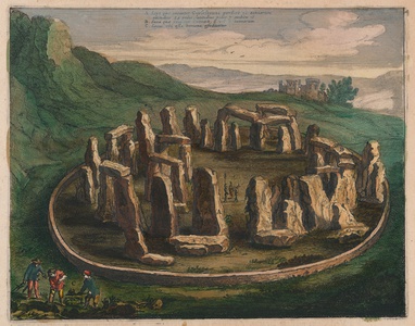
An atmospheric and somewhat romantic seventeenth century view of Stonehenge, beautifully ornamented in full wash colour, from the 1645 Latin imprint of Blaeu's Atlas Maior. The stones are shown still encircled by a low precinct wall, while a trio of soldiers armed with halberds stands in the open space at the centre of the monument. In the bottom left corner of the plate, outside the wall, another trio excavate a number of graves, the skull and long bones from one resting on the grass nearby. The view was originally engraved to accompany Blaeu's map of the county of Wiltshire, and features as part of his description of the county, from the pre-Roman Belgae who occupied the region, through to Arthurian era stories and even a brief history of the Seymour family and Wolf Hall. The Blaeu family were one of the most famous publishers of maps, globes and atlases during the seventeenth-century. Cartographers, globe makers and booksellers, the Blaeu business flourished in Amsterdam for over 40 years, until a fire destroyed their premises in 1672. They lost all of their plates, prints and stock, which effectively ruined the firm. Willem Blaeu founded the business in 1596. It initially functioned as a globe and instrument makers, but soon expanded into maps, topography and sea charts. The Atlas Novus was Willems great work, a major work which he intended to include the most up-to-date maps of the entire world. He issued the first two volumes in 1635, but died in 1638 before the atlas was completed. The running of the business was passed on to his sons Johannes and Cornelius, in addition to the role of the official cartographer of the East India Company. After the death of Cornelis in 1644, Johannes continued the business alone and established his own reputation as a great mapmaker. Johannes completed his father's grand project in 1655 with the sixth and final volume of the Atlas Novus. He also produced the Tooneel der Steden van der Vereenighde Nederlanden in 1649-1653, as well as a similar set of Italian town plans which were published in 1663. Condition: Minor time toning to sheet. Marginal tears to top and bottom of sheet, not affecting image or text. Latin text above, below, and on verso of sheet. |
| Framing | unmounted |
| Price | £275.00 |
| Stock ID | 52970 |

