
| Method | Woodcut with hand colour |
| Artist | Fries, Lorenz after Waldseemüller, Martin |
| Published | [Gaspar Trechsel, Vienne, 1541] |
| Dimensions | 285 x 455 mm |
| Notes |
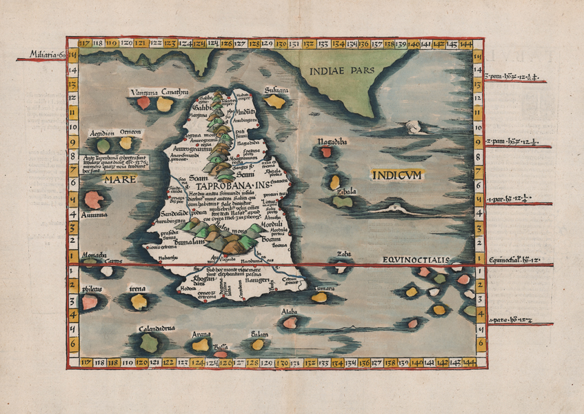
An attractively hand coloured map of Taprobana, now Sri Lanka, from Lorenz Fries' edition of Ptolemy's Geography, this example the 1541 Vienne printing by the Lyonnais publisher Gaspar Trechsel, with descriptive text by the Spanish humanist Michael Servetus on the verso. Stylistically, the map is a very close copy of Waldseemuller's 1513 woodcut map of Sri Lanka, though Fries' block extends further east to encompass more of the Indian Ocean, the surrounding islands, and a larger part of the Indian subcontinent. The equator runs through the southern part of the island, and lines along the left and right borders of the map provide parallels north and south of the equinoctial. Two sets of mountain ranges are depicted pictorially, and principal cities and towns are picked out with red dots. The rest of the map is further embellished in beautiful hand colour. On the verso, two panels of Latin letterpress text describe the island and its history. At the time of publication, there was significant confusion and debate over the identity of the Taprobana attested in the classical corpus, with some geographers, like here, favouring Sri Lanka, others Sumatra, and yet others an otherwise unknown or phantom island. Fries' maps were published in four different editions, by Gruninger in Strasbourg in 1522 and 1525, and, following Fries' death in 1532, by Johann Trechsel in Lyon and Vienne in 1535 and 1541. The Trechsel editions featured text by the Spanish humanist, Michael Servetus, writing in this case under the name Villanovus. Unfortunately for Servetus, his theological treatises drew negative attention from Protestant and Catholic corners alike, and in 1553 he was found guilty of heresy and burned at the stake, and this put paid to any future editions of Fries' atlas. The woodcut borders on the versos of Gruninger and Trechsel's editions are traditionally attributed to Hans Holbein and Durer respectively. Lorenz Fries (c.1490-1532) was born in the Alsace region and studied variously at the universities in Pavia, Vienna, Piacenza and Montpellier. After completing his studies, Fries set himself up as a physician in Alsace, and briefly in Switzerland, before finally settling in Strasbourg in 1519, by which point he had published several medical texts. It was in Strasbourg that Fries meet Johann Gruniger, an associate of the St. Die group of scholars who included Martin Waldseemüller. From 1520 to 1525 Fries worked with Gruniger as his cartographic editor, producing numerous reduced woodblock maps using the vast material of Waldseemüller's 1513 Ptolemaic Atlas. Martin Waldseemüller (11th September, 1470 - 16th March, 1520) was a German author, cartographer, and publisher, and one of the most significant figures in the history of cartography. His most celebrated achievement was the publication in 1507 of his Universalis Cosmographia, a monumental twelve-panel map of the world making use of the discoveries of Columbus and Vespucci, and being the first recorded use of the title 'America' to describe the New World. In addition to this, Waldseemuller's appendix to his Ptolemaic atlas featured some of the very first individual maps of European discoveries in the New World, East Indies, and Western and Southern Africa. Condition: Central vertical fold, as issued. Minor creasing and time toning to sheet. Repaired insect damage to bottom margin, not affecting map. Latin text on verso. |
| Framing | unmounted |
| Price | £950.00 |
| Stock ID | 52792 |