
| Method | Copper engraved |
| Artist | Jansson, Jan |
| Published | [Jan Jansson, Amsterdam, c.1653] |
| Dimensions | Each plate ~410 x 510 mm |
| Notes |
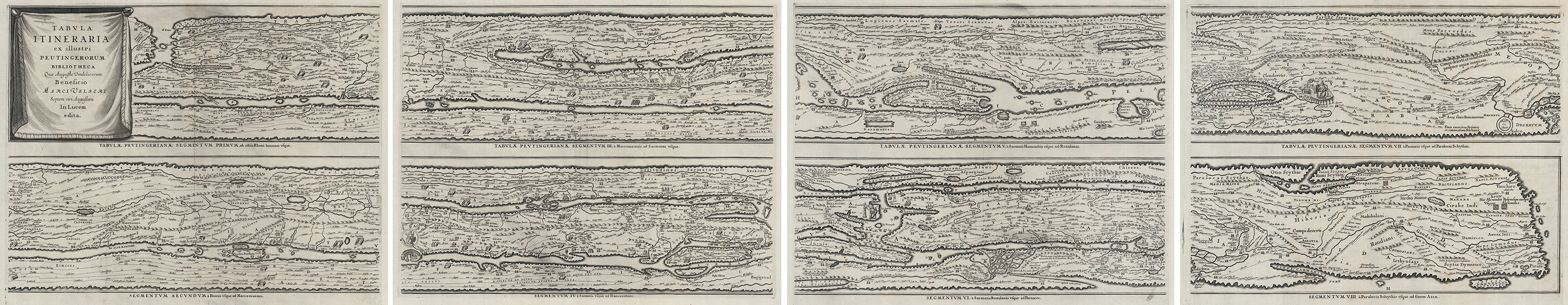
Jansson's finely engraved edition of the celebrated Peutinger Map, a manuscript scroll showing the cursus publicus, the ancient Roman road network. The map, here engraved in eight panels and printed over four sheets, stretches from eastern England and the Iberian peninsula in the west, to India in the East. If joined into a single panel in mimicry of the original parchment scroll, the map would present an unusually distorted but highly detailed projection of the Roman Empire and its neighbours, extensively illustrated with cities, towns, trading posts, ports, natural topography, tribal and provincial divisions, and annotations of natural, economic, and historical significance. The cities of Rome, Constantinople, and Antioch are given special prominence, depicted as large figural roundels, while the road system is annotated with distances. On the fringes of the Roman world, textual notes show the furthest extent of the campaigns of Alexander, pirates near the island of Taprobana (Sri Lanka), and the origin of scorpions and elephants in the foothills of the Indian subcontinent. The history of the map's production is almost as interesting as the physical map itself. The current example was originally issued by Jansson in 1652 in his Accuratissima Orbis Antiqui Delineatio, a suite of maps of the classical world in the model of Ortelius' celebrated Parergon. The following year, Jansson's maps were accompanied by a descriptive text written by the antiquarian Georg Hornius, and became the sixth volume of the Jansson Atlas Novus. Like the rest of the maps in Jansson's atlas, the Tabula Itineraria was also a close copy of an earlier example produced by Ortelius. Ortelius' own attempt, cut short by his death in 1598, meant that the first printings of the complete engraved Tabula Itineraria were posthumous, printed by Moretus in later editions of the Parergon. The origins of the manuscript upon which the engraved examples are based are, however, more obscure. The original manuscript map was brought to Ortelius' attention by Marcus Welser (1558-1614), the Augsburg banker, whose prominent position in the court of the Emperor Charles V put him in contact with intellectual circles across Europe. Welser was a kinsman of the humanist scholar Konrad Peutinger, who had received the map in a 1508 bequest from the Franconian scholar and so-called 'Archhumanist' Conrad Celtes, who allegedly discovered the manuscript in 1494 in a library in Worms. Celtes, even in his own time, was suspected of having stolen the map, as part of an active and targeted campaign of book and document thefts carried out on behalf of Maximilian I. The details of the map's discovery may, as a result, have been deliberately obscured, and suggestions for its origin vary. Although the map may be a genuine creation of the twelfth century, a thirteen century Colmar monk, or even the Carolingian period, scholarly consensus is that the map is a medieval reproduction closely based upon a Roman original from late antiquity, most probably the early fifth century. This putative late antique map was almost certainly based upon an earlier map of the Imperial period. Ortelius and Jansson both compare it to an Itinerarium from the reign of Antoninus Pius, though the inclusion of Pompeii, destroyed in AD 79, strongly suggests that the original map was a product of the Julio-Claudian period. Most scholars believe that the ultimate source was the famous map prepared by Agrippa during the reign of Augustus and displayed in the Porticus Vipsania, though anachronisms like the prominence of Ravenna and Constantinople, as well as the inclusion of the state of Francia, are almost certainly examples of reworkings or emendations from late antiquity. The surviving manuscript, having remained with the Peutinger family for two centuries, was eventually purchased in the early eighteenth century by Prince Eugene of Savoy. It is now in the collections of the Austrian National Library in Vienna, having been purchased for the Habsburg Imperial Court Library from Prince Eugene's estate in 1737. Johannes Janssonius (1588-1664) was a famed cartographer and print publisher. More commonly known as Jan Jansson, he was born in Arnhem where his father, Jan Janszoon the Elder, was a bookseller and publisher. In 1612 he married the daughter of the cartographer and publisher Jodocus Hondius, and then set up in business in Amsterdam as a book publisher. In 1616 he published his first maps of France and Italy and from then onwards, produced a very large number of maps which went some way to rival those of the Blaeu family, who held a virtual monopoly over the industry. From about 1630 to 1638 he was in partnership with his brother-in-law, Henricus Hondius, issuing further editions of the Mercator/Hondius atlases to which his name was added. On the death of Hondius he took over the business, expanding the atlas still further, until eventually he published an eleven volume Atlas Major on a scale similar to Johannes Blaeu's magnum opus. After Jansson's death, his heirs published a number of maps in the Atlas Contractus of 1666, and, later still, many of the plates of his British maps were acquired by Pieter Schenk and Gerard Valck, who published them again in 1683 as separate maps. Condition: Central vertical folds, as issued. Some minor creasing to central folds and corners of sheets. Minor creasing and time toning to margins, not affecting maps. Small chip to top of central fold on Plate 1 and small tears to top of central fold on Plates 3 and 4, not affecting maps. Blank on versos. |
| Framing | unmounted |
| Price | £5,000.00 |
| Stock ID | 53271 |