| Method | Copper engraved with original hand colour |
| Artist | Moll, Herman |
| Published | Printed for H. Moll over against Devereux Court without Temple Bar. I. Bowles at ye sign of ye Screen over against Stocks Market and Tho. Bowles Print and Mapseller next to the Chapter House in St. Pauls Churchyard… Sold by Philip Overton Map and Printseller near St. Dunstans Church Fleet Street. And by John King at the Globe in the Poultry. c.1730 |
| Dimensions | 605 x 967 mm |
| Notes |
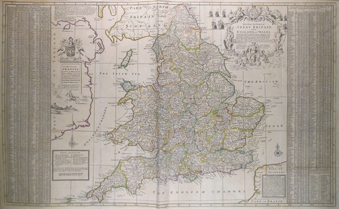
Full title: The South Part of Great Britain, called England and Wales. Containing all ye Cities, Market Towns, Boroughs: And whatever Places have ye Election of Members of Parliament with ye Names of ye Rivers, Seaports, Sands, Hills, Moors, Forests &c. All ye Great or Port Roads, and principal Cross Roads, &c. With ye Computed Miles from Town to Town, and all ye Post Towns, as they are at present regulated by the Postmasters Gen.l of the General Post House. A large-scale and incredibly detailed two sheet map of England and Wales flanked by two exhaustive tables listing "all ye Cities, Market Towns, Boroughs and whateve Places in South Britain have ye Election of Members of Parliament." An elaborate allegorical title cartouche to the top right, surrounded by sailing ships in the "British Ocean". An "Advertisement" in the bottom right corner outlines Moll's appreciation for John Ogilby's road maps published in 1675 and commenting on mistakes made by other mapmakers that have failed to take on board the latest and most correct observations. The map is further ornamented with a dedication to "Right Honourable FRANCIS, Lord Viscount Rialton Son and Heir apparent of the Right Hon.ble Sidney Earl of Godolphin & c. Lord High Treasurer of Great Britain. This Map of South Britain is most Humbly Dedicated by your Lordship's most Humble Servant Herman Moll Geographer." and a clear explanation key set below a compass rose. The title 'South Britain' stems from the Act of Union between England and Scotland in 1707, with Scotland being labelled 'North Britain'. Herman Moll (c.1654-1732) was born in Germany and came to England in the 1670s. He worked as an independent cartographer and geographer, and traded as a map publisher and seller for two years, and then worked for other publishers. Moll established his own business and eventually dominated the early eighteenth century map trade. He produced many maps and atlases of England, Wales, Scotland and Ireland. His county maps were all boldly engraved in a heavy style. Moll was also an active member in academic and intellectual circles, being a close associate of Daniel Defoe, Robert Boyle, Robert Hooke, and, most importantly for his cartographic career, the pre-eminent English explorer of the era, William Dampier. R.W. Shirley. Printed Maps of the British Isles 1650 - 1750. Moll 6. state 5. Condition: Excellent clean impression. Printed on two sheets and joined, as issued. Small professionally repaired hole to north riding of Yorkshire. Pressed vertical and horizontal folds |
| Framing | unmounted |
| Price | £750.00 |
| Stock ID | 42269 |

