| Method | Copper engraved with hand colour |
| Artist | Ortelius, Abraham |
| Published | Ex conatibus Geographicis Abrah. Ortelij. Cum Imp. et Belgico privilegio decennali 1585. [1624 Parergon] |
| Dimensions | 356 x 478 mm |
| Notes |
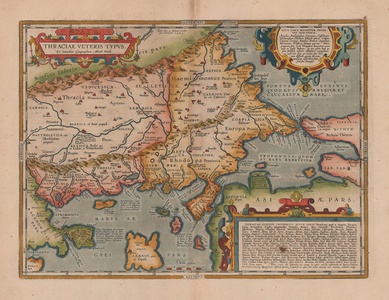
A map of ancient Thrace, roughly corresponding to modern day Bulgaria, northern Greece, and the European part of Turkey, originally engraved in 1585 for the 1590 Parergon (Supplement) of Ortelius' famous Theatrum Orbis Terrarum. This particular example is from the final 1624 Latin printing of the Parergon. The map depicts the extent of the ancient tribal lands of the Thracians, with particular reference to the Odyrysian kingdom, a loose confederation of tribes that existed following the expulsion of the Persians in the fifth century BC, until the first century AD when it was subsumed by the Roman empire. The map also shows parts of the surrounding territories of Moesia, between the Danube and the Haemus Mountains, Macedonia, Bithynia, Asia, the Aegean islands of Lemnos, Thasos, Samos (Samothrace), Imbros, and Tenedos, as well as part of the Black Sea, the Propontis, and the northern Aegean. The map is ornamented in beautiful hand colour, and principal geographic features are shown, including the two mountain ranges of the Haemus and Rhodope, named after the mythic king of Thrace and his queen, who were transformed into mountains after having the temerity to compare themselves to Zeus and Hera. Principal cities and towns are picked out in red, the most significant of which, Byzantium, Cyzicus, and Philippopolis, are given extra descriptive text. The Thracian tribe of the Cicones, made famous in their bloody struggles against Odysseus in Book 9 of Homer's Odyssey, occupy a coastal valley to the south of Traianopolis, and the mythical stables of Diomedes are plotted on the coastline across from the island of Thasos. The horses stabled within were the object of one of Hercules' labours, and, later, were considered the sires of Alexander's horse, Bucephalus. The site of the famous battle of Philippi, in which Brutus and Cassius were defeated by the Caesarian forces under Antony and Octavian, can be seen to the north of the promontory of the holy site of Mount Athos. The map is further embellished by a trio of strap-work cartouches. The first, enclosing the title, also features the word 'Thrace' written in Greek capitals, while the other two contain lists of place names of unknown location, in Thrace generally, and within the region surrounding Byzantium. On the verso, copious notes in Latin provide a history of the region, with particular reference to Byzantium and Constantinople, as well as a discussion of classical source traditions for the racial and linguistic features of various Thracian tribes. The Parergon ('Supplement') was, as the title suggests, originally conceived of as a supplement to Ortelius' Theatrum. The work, a massive and intricately researched index of the classical world, was accompanied by a series of ancient world maps. Unlike the maps of the Theatrum, the majority of which were reductions of earlier maps, the maps of the Parergon were researched and drawn by Ortelius himself. The work was a huge commercial success, and the maps themselves set the standard for ancient world maps for the duration of the seventeenth century, being reproduced or reprinted by various publishers after Ortelius' final 1624 printing. His interest in the mapping of the ancient world is manifest. The maps of the Parergon are a veritable mine of textual commentary and classical philology, drawing upon Ptolemy, Strabo, Pliny, and many others. Interestingly, the project seems to have been a labour of love, rather than a mercantile venture. Ortelius himself was fascinated with the ancient world, and a formidable classical scholar in his own right. In addition to his work as a cartographer, he dealt in antiquities, visited and surveyed ancient sites across Europe, published a critical edition of Caesar's Gallic Wars in 1593, and assisted Welser in his studies of the famous Tabula Peutingeriana in 1598, producing an engraved copy of the map that can be found in later editions of the Parergon. Abraham Ortelius (1527 -1598) was a Flemish cartographer, cosmographer, geographer and publisher and a contemporary of Gerard Mercator, with whom he travelled through Italy and France. Although it is Mercator who first used the word "Atlas" as a name for a collection of maps, it is Ortelius who is remembered as the creator of the first modern atlas. Theatrum Orbis Terrarum was the first systematically collated set of maps by different map makers in a uniform format. Three Latin editions as well as a Dutch, French and German edition of Theatrum Orbis Terrarum were published by 1572 and a further 25 editions printed before Ortelius' death in 1598. Several more were subsequently printed until around 1612. Ortelius is said to have been the first person to pose the question of the continents once being a single land mass before separating into their current positions. Condition: Central vertical fold, as issued. Time toning and minor foxing to central fold and margins. Burn mark to centre of boxed text in bottom right corner of map. Latin text on verso. |
| Framing | unmounted |
| Price | £700.00 |
| Stock ID | 52527 |

