
| Method | Chromolithograph |
| Artist | [Anonymous] |
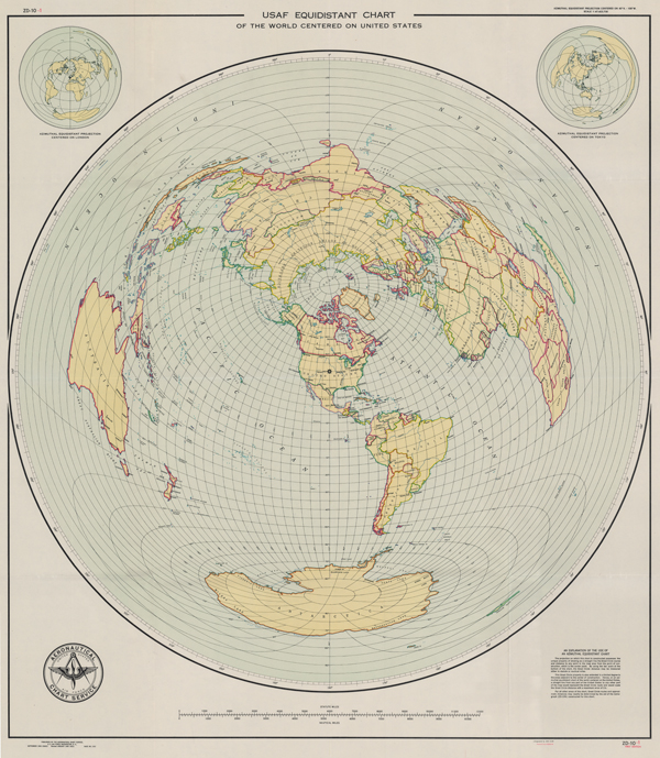
| Published | Published by the Aeronautical Chart Service, U.S. Air Force, Washington, D.C. September 1946, Revised January 1949. |
| Dimensions | 1010 x 870 mm |
| Notes |
A large and colourful mid-century map of the world centred on the United States of America, originally issued in 1946 by the United States Air Force. This particular example is the first edition of a 1949 revision of the original map, likely in response to geopolitical considerations following the announcement of the Truman Doctrine in 1947 and the early years of the Cold War. The map shows the Earth on an aximuthal equidistant projection, allowing the viewer to plot distances in Statute and Nautical Miles to any position on the globe from the continental United States. The map is centred on the USA, with a star marking a location roughly between Denver and Kansas City. The central vertical line thus forms the Great Circle course, passing through Canada, the USSR, China, India, Antarctica, and Mexico. Of most note at the time of printing would no doubt have been the proximity thus measured on the line to the Russian city of Novosibirsk (New Siberia), which during the course of the 1940s had grown rapidly, becoming a centre for manufacture and a critical supply base for the Red Army. National borders are outlined in chromolithographed colour, and a pair of smaller circles in the top left and right show the same projection centred on London and Tokyo respectively. In the bottom left corner, the crest of the US Air Force's Aeronautical Chart Service is emblazoned, while a descriptive text in the bottom right provides a guide to the map's use. Condition: Horizontal and vertical folds, as issued. Small pinholes to top corners of sheet. Minor dirt staining to folds, otherwise a clean crisp example. Blank on verso. |
| Framing | unmounted |
| Price | £400.00 |
| Stock ID | 52748 |